
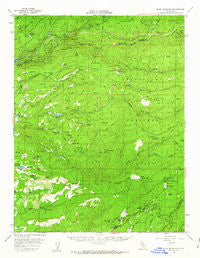
~ Blue Mountain CA topo map, 1:62500 scale, 15 X 15 Minute, Historical, 1956, updated 1963
Blue Mountain, California, USGS topographic map dated 1956.
Includes geographic coordinates (latitude and longitude). This topographic map is suitable for hiking, camping, and exploring, or framing it as a wall map.
Printed on-demand using high resolution imagery, on heavy weight and acid free paper, or alternatively on a variety of synthetic materials.
Topos available on paper, Waterproof, Poly, or Tyvek. Usually shipping rolled, unless combined with other folded maps in one order.
- Product Number: USGS-5500625
- Free digital map download (high-resolution, GeoPDF): Blue Mountain, California (file size: 9 MB)
- Map Size: please refer to the dimensions of the GeoPDF map above
- Weight (paper map): ca. 55 grams
- Map Type: POD USGS Topographic Map
- Map Series: HTMC
- Map Verison: Historical
- Cell ID: 51554
- Scan ID: 296850
- Imprint Year: 1963
- Woodland Tint: Yes
- Aerial Photo Year: 1955
- Field Check Year: 1956
- Datum: NAD27
- Map Projection: Polyconic
- Map published by United States Geological Survey
- Map published by United States Army
- Map Language: English
- Scanner Resolution: 600 dpi
- Map Cell Name: Blue Mountain
- Grid size: 15 X 15 Minute
- Date on map: 1956
- Map Scale: 1:62500
- Geographical region: California, United States
Neighboring Maps:
All neighboring USGS topo maps are available for sale online at a variety of scales.
Spatial coverage:
Topo map Blue Mountain, California, covers the geographical area associated the following places:
- Blue Lake Springs - Big Trees Village - White Pines - Mountain Retreat - Porter - Fuchs - Grizzly Ridge - Sandoz - Big Trees - Snowshoe Springs - Arnold - Manuel Mill - Mumbert Acres - Golden Torch Trailer Park - Camp Connell - Lakeside Terrace - Lilac Park - Hams - Blue Lake Junction - Dorrington - Fort Jones
- Map Area ID: AREA38.538.25-120.5-120.25
- Northwest corner Lat/Long code: USGSNW38.5-120.5
- Northeast corner Lat/Long code: USGSNE38.5-120.25
- Southwest corner Lat/Long code: USGSSW38.25-120.5
- Southeast corner Lat/Long code: USGSSE38.25-120.25
- Northern map edge Latitude: 38.5
- Southern map edge Latitude: 38.25
- Western map edge Longitude: -120.5
- Eastern map edge Longitude: -120.25


