
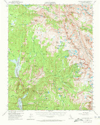
~ Blackcap Mtn CA topo map, 1:62500 scale, 15 X 15 Minute, Historical, 1962, updated 1972
Blackcap Mtn, California, USGS topographic map dated 1962.
Includes geographic coordinates (latitude and longitude). This topographic map is suitable for hiking, camping, and exploring, or framing it as a wall map.
Printed on-demand using high resolution imagery, on heavy weight and acid free paper, or alternatively on a variety of synthetic materials.
Topos available on paper, Waterproof, Poly, or Tyvek. Usually shipping rolled, unless combined with other folded maps in one order.
- Product Number: USGS-5500573
- Free digital map download (high-resolution, GeoPDF): Blackcap Mtn, California (file size: 9 MB)
- Map Size: please refer to the dimensions of the GeoPDF map above
- Weight (paper map): ca. 55 grams
- Map Type: POD USGS Topographic Map
- Map Series: HTMC
- Map Verison: Historical
- Cell ID: 51484
- Scan ID: 296822
- Imprint Year: 1972
- Woodland Tint: Yes
- Aerial Photo Year: 1948
- Field Check Year: 1953
- Datum: NAD27
- Map Projection: Polyconic
- Map published by United States Geological Survey
- Map Language: English
- Scanner Resolution: 600 dpi
- Map Cell Name: Blackcap Mountain
- Grid size: 15 X 15 Minute
- Date on map: 1962
- Map Scale: 1:62500
- Geographical region: California, United States
Neighboring Maps:
All neighboring USGS topo maps are available for sale online at a variety of scales.
Spatial coverage:
Topo map Blackcap Mtn, California, covers the geographical area associated the following places:
- Courtright Intrusive Contact Zone Geological Area - McGuire Lakes - Schoolmarm Lake - Franklin Meadow - Potholes - Halfmoon Lake - Fleming Creek - Burnt Corral Meadow - Reddys Hole - Burnt Corral Creek - Crabtree Lake - Summit Lake - Twin Buck Lakes - Turf Lakes - Upper Indian Lake - Loper Peak - Boulder Creek Campground - Double Meadow - Castle Ridge - Little Shot Lake - Zingheim Heights - Clear Lake - Piute Canyon - Ward Mountain Lake - Hell for Sure Pass - Woodchuck Creek - Mosquito Pass - Evolution Creek - Six Shooter Lake - Devils Punchbowl - Lobe Lakes - Courtwright 97-119 Dam - Hummingbird Lake - Short Hair Creek - Courtright Reservoir - Red Rock Basin - Bighorn Lake - Red Mountain - Big Maxson Meadow - Lower Blayney Campground - Lost Peak - Chimney Lake - Heather Lake - Hot Springs - Jigger Lakes - Scepter Lake - Evolution Valley - John Muir Rock - Fall Creek - Horseshoe Lake - China Camp - Thompson Lake - Hobler Lake - Rainbow Lake - Blackcap Mountain - Holster Lake - Rae Lake - Voyager Rock Campground - Meadow Brook Cabin - Crown Lake - Maxson Basin - Evolution Meadow - Division Lake - Blackrock Lake - Long Meadow - West Pinnacles Creek - Colt Lake - Blackcap Basin - Bonita Lake - Mount Hutton - Chuck Pass - Dusy Meadow - Hot Springs Pass - Horseshoe Lake - Woodchuck Country - Woodchuck Lake - Matthes Glaciers - Maxson Lake - Lily Pad Campground - Little Jo Lake - Sallie Keyes Creek - Maxson Meadows - Lower Indian Lake - Guest Lake - Ram Lake - Goddard Canyon - Lone Doe Lake - Emerald Peak - Dale Lake - Meadow Brook - North Goddard Creek - Fleming Lake - Filly Lake - Moore Boys Camp - Sharp Creek - Shooting Star Meadow - Nichols Canyon - Chamberlains Camp - Wishon Dam - Lost Lake
- Map Area ID: AREA37.2537-119-118.75
- Northwest corner Lat/Long code: USGSNW37.25-119
- Northeast corner Lat/Long code: USGSNE37.25-118.75
- Southwest corner Lat/Long code: USGSSW37-119
- Southeast corner Lat/Long code: USGSSE37-118.75
- Northern map edge Latitude: 37.25
- Southern map edge Latitude: 37
- Western map edge Longitude: -119
- Eastern map edge Longitude: -118.75


