
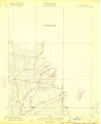
~ Singer Creek CA topo map, 1:31680 scale, 7.5 X 7.5 Minute, Historical, 1912, updated 1922
Singer Creek, California, USGS topographic map dated 1912.
Includes geographic coordinates (latitude and longitude). This topographic map is suitable for hiking, camping, and exploring, or framing it as a wall map.
Printed on-demand using high resolution imagery, on heavy weight and acid free paper, or alternatively on a variety of synthetic materials.
Topos available on paper, Waterproof, Poly, or Tyvek. Usually shipping rolled, unless combined with other folded maps in one order.
- Product Number: USGS-5500013
- Free digital map download (high-resolution, GeoPDF): Singer Creek, California (file size: 4 MB)
- Map Size: please refer to the dimensions of the GeoPDF map above
- Weight (paper map): ca. 55 grams
- Map Type: POD USGS Topographic Map
- Map Series: HTMC
- Map Verison: Historical
- Cell ID: 37789
- Scan ID: 296511
- Imprint Year: 1922
- Survey Year: 1910
- Datum: NAD
- Map Projection: Polyconic
- Map published by United States Geological Survey
- Map Language: English
- Scanner Resolution: 600 dpi
- Map Cell Name: Richardson Springs NW
- Grid size: 7.5 X 7.5 Minute
- Date on map: 1912
- Map Scale: 1:31680
- Geographical region: California, United States
Neighboring Maps:
All neighboring USGS topo maps are available for sale online at a variety of scales.
Spatial coverage:
Topo map Singer Creek, California, covers the geographical area associated the following places:
- Deer Creek Ranch Airport - Cone Kimball Ditch - Rattlesnake Creek - Stephens Ranch - Zimmershed Creek - McKenzie Ranch - Brush Creek - Carter Cemetery - Bell Ranch - Deer Creek Irrigation Ditch - Middle Fork Brush Creek - West Fork Brush Creek - Juniper Gulch - Live Oak School - Deer Creek Flat Trail - Campbell Creek - Vandergrift Lake
- Map Area ID: AREA4039.875-122-121.875
- Northwest corner Lat/Long code: USGSNW40-122
- Northeast corner Lat/Long code: USGSNE40-121.875
- Southwest corner Lat/Long code: USGSSW39.875-122
- Southeast corner Lat/Long code: USGSSE39.875-121.875
- Northern map edge Latitude: 40
- Southern map edge Latitude: 39.875
- Western map edge Longitude: -122
- Eastern map edge Longitude: -121.875


