
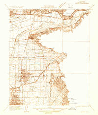
~ Orange CA topo map, 1:31680 scale, 7.5 X 7.5 Minute, Historical, 1932
Orange, California, USGS topographic map dated 1932.
Includes geographic coordinates (latitude and longitude). This topographic map is suitable for hiking, camping, and exploring, or framing it as a wall map.
Printed on-demand using high resolution imagery, on heavy weight and acid free paper, or alternatively on a variety of synthetic materials.
Topos available on paper, Waterproof, Poly, or Tyvek. Usually shipping rolled, unless combined with other folded maps in one order.
- Product Number: USGS-5499775
- Free digital map download (high-resolution, GeoPDF): Orange, California (file size: 6 MB)
- Map Size: please refer to the dimensions of the GeoPDF map above
- Weight (paper map): ca. 55 grams
- Map Type: POD USGS Topographic Map
- Map Series: HTMC
- Map Verison: Historical
- Cell ID: 33332
- Scan ID: 296370
- Survey Year: 1932
- Datum: NAD27
- Map Projection: Polyconic
- Advance: Yes
- Map published by United States Geological Survey
- Keywords: Nonstandard Press Run
- Map Language: English
- Scanner Resolution: 600 dpi
- Map Cell Name: Orange
- Grid size: 7.5 X 7.5 Minute
- Date on map: 1932
- Map Scale: 1:31680
- Geographical region: California, United States
Neighboring Maps:
All neighboring USGS topo maps are available for sale online at a variety of scales.
Spatial coverage:
Topo map Orange, California, covers the geographical area associated the following places:
- Orange Mobile Home Park - Creekside Mobile Home Estates - Carriage Mobile Home Estates - Hacienda Mobile Home Park - Orange Park Acres - Wanda (historical) - Orange - Anaheim Hills - Atwood - Placentia - Yorba - Olive - El Modena - Richfields - Lemon Heights - La Paloma - Friendly Village of Anaheim - North Tustin - Orange Village Mobile Home Park - Hewes Park - Peralta Hills - McPherson - Rio Vista Mobile Home Estates - Panorama Heights - Goforth Mobile Home Village - Cerro Villa Heights - Cowan Heights - Del Cerro Mobile Home Estates - Villa Park - Marlboro
- Map Area ID: AREA33.87533.75-117.875-117.75
- Northwest corner Lat/Long code: USGSNW33.875-117.875
- Northeast corner Lat/Long code: USGSNE33.875-117.75
- Southwest corner Lat/Long code: USGSSW33.75-117.875
- Southeast corner Lat/Long code: USGSSE33.75-117.75
- Northern map edge Latitude: 33.875
- Southern map edge Latitude: 33.75
- Western map edge Longitude: -117.875
- Eastern map edge Longitude: -117.75


