
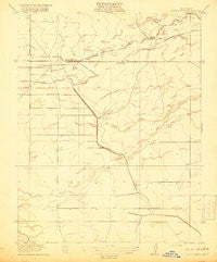
~ Bliss Ranch CA topo map, 1:31680 scale, 7.5 X 7.5 Minute, Historical, 1918
Bliss Ranch, California, USGS topographic map dated 1918.
Includes geographic coordinates (latitude and longitude). This topographic map is suitable for hiking, camping, and exploring, or framing it as a wall map.
Printed on-demand using high resolution imagery, on heavy weight and acid free paper, or alternatively on a variety of synthetic materials.
Topos available on paper, Waterproof, Poly, or Tyvek. Usually shipping rolled, unless combined with other folded maps in one order.
- Product Number: USGS-5499035
- Free digital map download (high-resolution, GeoPDF): Bliss Ranch, California (file size: 4 MB)
- Map Size: please refer to the dimensions of the GeoPDF map above
- Weight (paper map): ca. 55 grams
- Map Type: POD USGS Topographic Map
- Map Series: HTMC
- Map Verison: Historical
- Cell ID: 4388
- Scan ID: 295936
- Survey Year: 1916
- Datum: Unstated
- Map Projection: Unstated
- Map published by United States Geological Survey
- Map Language: English
- Scanner Resolution: 600 dpi
- Map Cell Name: Bliss Ranch
- Grid size: 7.5 X 7.5 Minute
- Date on map: 1918
- Map Scale: 1:31680
- Geographical region: California, United States
Neighboring Maps:
All neighboring USGS topo maps are available for sale online at a variety of scales.
Spatial coverage:
Topo map Bliss Ranch, California, covers the geographical area associated the following places:
- Ashview Lateral A - Red Top - Mansada Ranch - Vlot Dairy and Heifer Ranch - Ashview Canal - Chowchilla Ranch - Hughes Canal - Red Top Airport (historical) - Silveira Dairy - Bliss Ranch - Ash Slough - Coelho Farms Dairy - Troost Dairy - Chapman Farms Airport - Ashview School - Alamo School - Brasil Dairy - Red Top Ranch - Emmett Field - Justin Canal
- Map Area ID: AREA37.12537-120.5-120.375
- Northwest corner Lat/Long code: USGSNW37.125-120.5
- Northeast corner Lat/Long code: USGSNE37.125-120.375
- Southwest corner Lat/Long code: USGSSW37-120.5
- Southeast corner Lat/Long code: USGSSE37-120.375
- Northern map edge Latitude: 37.125
- Southern map edge Latitude: 37
- Western map edge Longitude: -120.5
- Eastern map edge Longitude: -120.375


