
~ Avenal Gap CA topo map, 1:31680 scale, 7.5 X 7.5 Minute, Historical, 1933
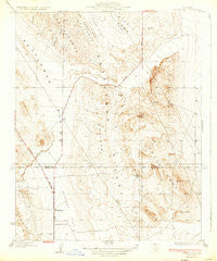
Avenal Gap, California, USGS topographic map dated 1933.
Includes geographic coordinates (latitude and longitude). This topographic map is suitable for hiking, camping, and exploring, or framing it as a wall map.
Printed on-demand using high resolution imagery, on heavy weight and acid free paper, or alternatively on a variety of synthetic materials.
Topos available on paper, Waterproof, Poly, or Tyvek. Usually shipping rolled, unless combined with other folded maps in one order.
- Product Number: USGS-5498989
- Free digital map download (high-resolution, GeoPDF): Avenal Gap, California (file size: 6 MB)
- Map Size: please refer to the dimensions of the GeoPDF map above
- Weight (paper map): ca. 55 grams
- Map Type: POD USGS Topographic Map
- Map Series: HTMC
- Map Verison: Historical
- Cell ID: 1942
- Scan ID: 295915
- Survey Year: 1930
- Datum: NAD
- Map Projection: Polyconic
- Map published by United States Geological Survey
- Map Language: English
- Scanner Resolution: 600 dpi
- Map Cell Name: Avenal Gap
- Grid size: 7.5 X 7.5 Minute
- Date on map: 1933
- Map Scale: 1:31680
- Geographical region: California, United States
Neighboring Maps:
All neighboring USGS topo maps are available for sale online at a variety of scales.
Spatial coverage:
Topo map Avenal Gap, California, covers the geographical area associated the following places:
- Boulder Hill - Las Perillas Pumping Plant - Devils Den School (historical) - Alamo Solo Spring - Avenal Gap - Arroyo Ancho - La Zanja - Oyster Hill - El Vallejo - Badger Hill - Pintojo Ridge - Devils Den Post Office (historical) - South Dome - Cascajo Hill - Las Perillas - El Arco - Los Morones - El Rincón - Governor Edmund G Brown Coastal Branch California Aqueduct - Cerro del Sur - El Vejón - El Rabo - Las Lomas - La Arena - Devils Den - Las Colinas - Arroyo Petreo - Pepper Grass Valley - Arroyo Tozo
- Map Area ID: AREA35.87535.75-120-119.875
- Northwest corner Lat/Long code: USGSNW35.875-120
- Northeast corner Lat/Long code: USGSNE35.875-119.875
- Southwest corner Lat/Long code: USGSSW35.75-120
- Southeast corner Lat/Long code: USGSSE35.75-119.875
- Northern map edge Latitude: 35.875
- Southern map edge Latitude: 35.75
- Western map edge Longitude: -120
- Eastern map edge Longitude: -119.875


