
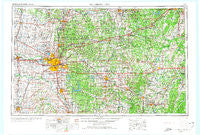
~ Oklahoma City OK topo map, 1:250000 scale, 1 X 2 Degree, Historical, 1957, updated 1974
Oklahoma City, Oklahoma, USGS topographic map dated 1957.
Includes geographic coordinates (latitude and longitude). This topographic map is suitable for hiking, camping, and exploring, or framing it as a wall map.
Printed on-demand using high resolution imagery, on heavy weight and acid free paper, or alternatively on a variety of synthetic materials.
Topos available on paper, Waterproof, Poly, or Tyvek. Usually shipping rolled, unless combined with other folded maps in one order.
- Product Number: USGS-5473181
- Free digital map download (high-resolution, GeoPDF): Oklahoma City, Oklahoma (file size: 18 MB)
- Map Size: please refer to the dimensions of the GeoPDF map above
- Weight (paper map): ca. 55 grams
- Map Type: POD USGS Topographic Map
- Map Series: HTMC
- Map Verison: Historical
- Cell ID: 68947
- Scan ID: 802350
- Imprint Year: 1974
- Woodland Tint: Yes
- Edit Year: 1968
- Field Check Year: 1957
- Datum: Unstated
- Map Projection: Transverse Mercator
- Map published by United States Geological Survey
- Map Language: English
- Scanner Resolution: 508 dpi
- Map Cell Name: Oklahoma City
- Grid size: 1 X 2 Degree
- Date on map: 1957
- Map Scale: 1:250000
- Geographical region: Oklahoma, United States
Neighboring Maps:
All neighboring USGS topo maps are available for sale online at a variety of scales.
Spatial coverage:
Topo map Oklahoma City, Oklahoma, covers the geographical area associated the following places:
- North Village - Bethel Acres - Pulaski - Tabler - Paden - Bellemont - Bookertee - Spring Hill - Ellaville - Hazel Dell - Watkins - Nichols Hills - Tribbey - Maguire - Shawnee Town (historical) - Nicoma Park - Haydenville - Heyburn - Depew - Indian Springs - Woodlawn Park - Clearview - Reeding - Morse - Needmore - Forest Park - Econtuchka - Harjo - Bethany - McKiddyville - Romulus - Yukon - Oklahoma City - Green Pastures - Willow View - Sacred Heart - Meeker - Crescent - Parkland - Clothier - Pharoah - Noble - Cottingham - Cushing - Lake Aluma - Okfuskee - Chandler - Valley Brook - Union City - Sooner - Tecumseh - Clifton - Rossville - Bridge Creek - Midway - Castle - Del City - Flynn - Moore - Meridian - Hibsaw - Tuskegee - Wheatland - IXL - Lillard Park - Shamrock - Slaughterville - Earlsboro - Kendrick - Emsey - Pink - Burnett - Soonerville - Gaddy - Tabor - Lima - Chickasha - Edmond - Bryant - Midway - Wetumka - Concho - Okemah - Fowler - Kiefer - Newby - Witcher - Aron - Lawrie - Bowlegs - Carney - Wilzetta - Mason - Dustin - Merrick - Nobletown - Cromwell - Prague - Stroud - Maud
- Map Area ID: AREA3635-98-96
- Northwest corner Lat/Long code: USGSNW36-98
- Northeast corner Lat/Long code: USGSNE36-96
- Southwest corner Lat/Long code: USGSSW35-98
- Southeast corner Lat/Long code: USGSSE35-96
- Northern map edge Latitude: 36
- Southern map edge Latitude: 35
- Western map edge Longitude: -98
- Eastern map edge Longitude: -96


