
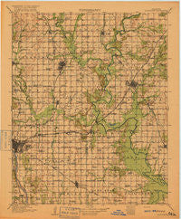
~ Claremore OK topo map, 1:125000 scale, 30 X 30 Minute, Historical, 1916
Claremore, Oklahoma, USGS topographic map dated 1916.
Includes geographic coordinates (latitude and longitude). This topographic map is suitable for hiking, camping, and exploring, or framing it as a wall map.
Printed on-demand using high resolution imagery, on heavy weight and acid free paper, or alternatively on a variety of synthetic materials.
Topos available on paper, Waterproof, Poly, or Tyvek. Usually shipping rolled, unless combined with other folded maps in one order.
- Product Number: USGS-5472893
- Free digital map download (high-resolution, GeoPDF): Claremore, Oklahoma (file size: 6 MB)
- Map Size: please refer to the dimensions of the GeoPDF map above
- Weight (paper map): ca. 55 grams
- Map Type: POD USGS Topographic Map
- Map Series: HTMC
- Map Verison: Historical
- Cell ID: 65211
- Scan ID: 802504
- Woodland Tint: Yes
- Survey Year: 1914
- Datum: Unstated
- Map Projection: Unstated
- Map published by United States Geological Survey
- Map Language: English
- Scanner Resolution: 508 dpi
- Map Cell Name: Claremore
- Grid size: 30 X 30 Minute
- Date on map: 1916
- Map Scale: 1:125000
- Geographical region: Oklahoma, United States
Neighboring Maps:
All neighboring USGS topo maps are available for sale online at a variety of scales.
Spatial coverage:
Topo map Claremore, Oklahoma, covers the geographical area associated the following places:
- Broken Arrow - Lynn Lane - Sequoyah - Limestone - Catoosa - Union - Turley - Elba - East Tulsa - Vera - Fair Oaks - Garnett - Keetonville - Verdigris - Sperry - Gregory - Mohawk - Osage Village (historical) - Mingo - Tiger - Jenks - Foyil - New Tulsa - Tulsa - Douglas - Tiawah - Oologah - Inola - McFarlin - Claremore - Sageeyah - Valley Park - Oneta - Alsuma - Collinsville - Oowala - Owasso - Justice - Degroat - Dawson - Edgewater Acres
- Map Area ID: AREA36.536-96-95.5
- Northwest corner Lat/Long code: USGSNW36.5-96
- Northeast corner Lat/Long code: USGSNE36.5-95.5
- Southwest corner Lat/Long code: USGSSW36-96
- Southeast corner Lat/Long code: USGSSE36-95.5
- Northern map edge Latitude: 36.5
- Southern map edge Latitude: 36
- Western map edge Longitude: -96
- Eastern map edge Longitude: -95.5


