
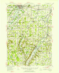
~ Batavia NY topo map, 1:62500 scale, 15 X 15 Minute, Historical, 1950, updated 1950
Batavia, New York, USGS topographic map dated 1950.
Includes geographic coordinates (latitude and longitude). This topographic map is suitable for hiking, camping, and exploring, or framing it as a wall map.
Printed on-demand using high resolution imagery, on heavy weight and acid free paper, or alternatively on a variety of synthetic materials.
Topos available on paper, Waterproof, Poly, or Tyvek. Usually shipping rolled, unless combined with other folded maps in one order.
- Product Number: USGS-5450587
- Free digital map download (high-resolution, GeoPDF): Batavia, New York (file size: 8 MB)
- Map Size: please refer to the dimensions of the GeoPDF map above
- Weight (paper map): ca. 55 grams
- Map Type: POD USGS Topographic Map
- Map Series: HTMC
- Map Verison: Historical
- Cell ID: 51002
- Scan ID: 123201
- Imprint Year: 1950
- Woodland Tint: Yes
- Aerial Photo Year: 1942
- Survey Year: 1950
- Datum: NAD27
- Map Projection: Polyconic
- Map published by United States Geological Survey
- Map Language: English
- Scanner Resolution: 600 dpi
- Map Cell Name: Batavia
- Grid size: 15 X 15 Minute
- Date on map: 1950
- Map Scale: 1:62500
- Geographical region: New York, United States
Neighboring Maps:
All neighboring USGS topo maps are available for sale online at a variety of scales.
Spatial coverage:
Topo map Batavia, New York, covers the geographical area associated the following places:
- Little Canada - Pavilion Center - Texaco Town - Buffalo Corners - Suicide Corners - Attica Center - Stafford - Spragues Corner - North Alexander - West Bethany - Belknap Crossing - Dale - Bethany Center - Wyoming - Ewells Corner - Burk Hill - Brookville - East Alexander - West Middlebury - Orangeville Center - Covington - East Bethany - Valley View Park - Wrights Corner - Junction - Thompsons Crossing - Pearl Creek - Hilltop Acres Mobile Home Park - Saltvale - Linden - Lambs Corner - Millers Crossing - Beehive Crossing - Pavilion - Roanoke - Lagrange - Paines Corner - Batavia - Millers Corner
- Map Area ID: AREA4342.75-78.25-78
- Northwest corner Lat/Long code: USGSNW43-78.25
- Northeast corner Lat/Long code: USGSNE43-78
- Southwest corner Lat/Long code: USGSSW42.75-78.25
- Southeast corner Lat/Long code: USGSSE42.75-78
- Northern map edge Latitude: 43
- Southern map edge Latitude: 42.75
- Western map edge Longitude: -78.25
- Eastern map edge Longitude: -78


