
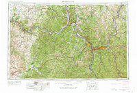
~ Huntington WV topo map, 1:250000 scale, 1 X 2 Degree, Historical, 1957, updated 1973
Huntington, West Virginia, USGS topographic map dated 1957.
Includes geographic coordinates (latitude and longitude). This topographic map is suitable for hiking, camping, and exploring, or framing it as a wall map.
Printed on-demand using high resolution imagery, on heavy weight and acid free paper, or alternatively on a variety of synthetic materials.
Topos available on paper, Waterproof, Poly, or Tyvek. Usually shipping rolled, unless combined with other folded maps in one order.
- Product Number: USGS-5416216
- Free digital map download (high-resolution, GeoPDF): Huntington, West Virginia (file size: 27 MB)
- Map Size: please refer to the dimensions of the GeoPDF map above
- Weight (paper map): ca. 55 grams
- Map Type: POD USGS Topographic Map
- Map Series: HTMC
- Map Verison: Historical
- Cell ID: 68832
- Scan ID: 254043
- Imprint Year: 1973
- Woodland Tint: Yes
- Photo Revision Year: 1966
- Field Check Year: 1957
- Datum: Unstated
- Map Projection: Transverse Mercator
- Map published by United States Geological Survey
- Map Language: English
- Scanner Resolution: 600 dpi
- Map Cell Name: Huntington
- Grid size: 1 X 2 Degree
- Date on map: 1957
- Map Scale: 1:250000
- Geographical region: West Virginia, United States
Neighboring Maps:
All neighboring USGS topo maps are available for sale online at a variety of scales.
Spatial coverage:
Topo map Huntington, West Virginia, covers the geographical area associated the following places:
- Haverhill - Wyoma - Ramey - Culver - Access - Northup - Owens Crossing - Martha - Freeman Estates - Belle Court - Glenroy - Aid - Craintown - Bluebank - Wrigley - Tomlison Addition - Beechy - Tara Estates - West Columbia - South Webster - Stark - Obad (historical) - Covedale - Minerva - Willard - Bogy-Chennault (historical) - Eifort - Willow Wood - Home Park - Leaper - Plummers Landing - Arlee - Lynn - Mount Olive - Dunkinsville - Globe - Poplar Grove - Spring Valley - Lesage - Newfoundland - Deering - Hickory Grove (historical) - Pinkerman - Greenup - Hurricane - Riverview - Shiloh - Kerr - Howards Mill - Sunset - Hannah - Jacobs - Pond Run - Hillsboro - Portersville - Angel - Cockrell Run - Beech Grove - Raccoon Island - Bladen - Midland - Burke - Bradyville - West Russell - Locust - York - Hobson Junction - Shrout (historical) - Owensville - Pleasant View - Chesapeake - Hidden Valley - Hogsett - Port Chardon Mobile Home Park - Dickson - Argillite - Bald Hill - Devil Fork (historical) - Harrisburg - Harveytown - Barboursville - Franklin Furnace - Rodburn - Andre - Fairview - Adams - Manchester - Eureka - Minford - Stockton (historical) - Neal - Cam Creek (historical) - Needmore (historical) - Higginsport - Slatey (historical) - Cloverdale (historical) - Lloyd - Hilda - Minor - Webbs Mill (historical)
- Map Area ID: AREA3938-84-82
- Northwest corner Lat/Long code: USGSNW39-84
- Northeast corner Lat/Long code: USGSNE39-82
- Southwest corner Lat/Long code: USGSSW38-84
- Southeast corner Lat/Long code: USGSSE38-82
- Northern map edge Latitude: 39
- Southern map edge Latitude: 38
- Western map edge Longitude: -84
- Eastern map edge Longitude: -82


