
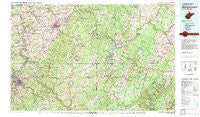
~ Morgantown WV topo map, 1:100000 scale, 30 X 60 Minute, Historical, 1979, updated 1983
Morgantown, West Virginia, USGS topographic map dated 1979.
Includes geographic coordinates (latitude and longitude). This topographic map is suitable for hiking, camping, and exploring, or framing it as a wall map.
Printed on-demand using high resolution imagery, on heavy weight and acid free paper, or alternatively on a variety of synthetic materials.
Topos available on paper, Waterproof, Poly, or Tyvek. Usually shipping rolled, unless combined with other folded maps in one order.
- Product Number: USGS-5416112
- Free digital map download (high-resolution, GeoPDF): Morgantown, West Virginia (file size: 31 MB)
- Map Size: please refer to the dimensions of the GeoPDF map above
- Weight (paper map): ca. 55 grams
- Map Type: POD USGS Topographic Map
- Map Series: HTMC
- Map Verison: Historical
- Cell ID: 67989
- Scan ID: 701697
- Imprint Year: 1983
- Woodland Tint: Yes
- Aerial Photo Year: 1979
- Edit Year: 1979
- Datum: NAD27
- Map Projection: Universal Transverse Mercator
- Map published by United States Geological Survey
- Map Language: English
- Scanner Resolution: 508 dpi
- Map Cell Name: Morgantown
- Grid size: 30 X 60 Minute
- Date on map: 1979
- Map Scale: 1:100000
- Geographical region: West Virginia, United States
Neighboring Maps:
All neighboring USGS topo maps are available for sale online at a variety of scales.
Spatial coverage:
Topo map Morgantown, West Virginia, covers the geographical area associated the following places:
- Pioneer Rocks - Bretz - Plummer - Searights - Blosser Hill - West Sabraton - Cats Run Junction - Little Chicago - Lower Peanut - Sand Spring - North Hills - Bruceton Mills - Hardy Hill - Mill Run Junction - Crucible - High Point - Lake Lynn - Casselman - Guseman - Herring - Edenborn - Helen - Hoyes Run - Somerfield - Graham Crossing - Trent - Morgan Heights - Leckrone - Stewartstown - Guseman (historical) - Florence (historical) - Morris Crossroads - Smiley - Sunset Beach - Newtown - Bitner - Addison - Keeny Row - Carmichaels - Laurel Falls - Stewarton - Dunlap Creek Village - Huston - Metzler - Hoard - Old Frame - Beachdale - Hayden (historical) - Elder Hill - New Centerville - Lenox - Shamrock - Brandonville - Bowest - Little Summit - Rockville - Evans - Pierpont - Sutherland (historical) - Jennings - Jaco - Church Hill - Salisbury Junction - Valley Point - Merrittstown - Indian Creek - Dunkard - Lambert - Wiles Hill - Tower Hill Number Two - Ringgold - Greer - Smock - Romania - Rocks Works - Dogwood Flats - Penn Pitt - Pineridge North - Brookhaven - Summit Mills - Cheat Neck - Mount Washington - York Run Junction - The Mileground - Superior - Allison Heights - Hibbs - Walnut Hill - Hatfield - Compton - Fairchance - Woodbridgetown - Engles Mill - Fayette - Park Hills - Sigsbee - Fairbank - Headlee Heights - Cascade - Maidsville
- Map Area ID: AREA4039.5-80-79
- Northwest corner Lat/Long code: USGSNW40-80
- Northeast corner Lat/Long code: USGSNE40-79
- Southwest corner Lat/Long code: USGSSW39.5-80
- Southeast corner Lat/Long code: USGSSE39.5-79
- Northern map edge Latitude: 40
- Southern map edge Latitude: 39.5
- Western map edge Longitude: -80
- Eastern map edge Longitude: -79


