
~ Marlinton WV topo map, 1:100000 scale, 30 X 60 Minute, Historical, 1979, updated 1982
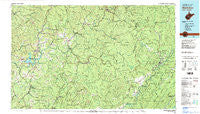
Marlinton, West Virginia, USGS topographic map dated 1979.
Includes geographic coordinates (latitude and longitude). This topographic map is suitable for hiking, camping, and exploring, or framing it as a wall map.
Printed on-demand using high resolution imagery, on heavy weight and acid free paper, or alternatively on a variety of synthetic materials.
Topos available on paper, Waterproof, Poly, or Tyvek. Usually shipping rolled, unless combined with other folded maps in one order.
- Product Number: USGS-5416110
- Free digital map download (high-resolution, GeoPDF): Marlinton, West Virginia (file size: 28 MB)
- Map Size: please refer to the dimensions of the GeoPDF map above
- Weight (paper map): ca. 55 grams
- Map Type: POD USGS Topographic Map
- Map Series: HTMC
- Map Verison: Historical
- Cell ID: 67909
- Scan ID: 701702
- Imprint Year: 1982
- Woodland Tint: Yes
- Edit Year: 1979
- Datum: NAD27
- Map Projection: Universal Transverse Mercator
- Map published by United States Geological Survey
- Map Language: English
- Scanner Resolution: 508 dpi
- Map Cell Name: Marlinton
- Grid size: 30 X 60 Minute
- Date on map: 1979
- Map Scale: 1:100000
- Geographical region: West Virginia, United States
Neighboring Maps:
All neighboring USGS topo maps are available for sale online at a variety of scales.
Spatial coverage:
Topo map Marlinton, West Virginia, covers the geographical area associated the following places:
- Mount Nebo - Nile - Friars Hill - Nettie - Holcomb - Tioga - Oscar - Clifftop - McClung (historical) - Harter - Webster Springs - Trout - Orient Hill - Leivasy - Halo - Bryant (historical) - Enoch - Beaver - Welch Glade - Honeydew (historical) - Violet - Lile - Gilboa - Slaty Fork - Strouds - Anjean - Medo - Clearco - Hillsboro - Keslers Cross Lanes - Dyer - Saxman - Nallen - Swandale - Opal - Glade Creek - Mingo - Donald - Cobb - Widen - Curtin - Craigsville - Zela - Thorny Creek - Cherry Falls - Pine Trailer Park - Birch River - Donaldson - Poe - Weese - Burnsides - Beard Heights - Cowen - Ophelia (historical) - Trainer - Russellville - Glade View - Holly Hills Estates - Renicks Valley - Allingdale - Snow Hill - Tolbert - Harriet - North Bend - Dille - Ravenseye - Leonard - Fowler Knob - Nutterville - Bergoo - Drennen - Tara Estates - Marlinton - Burl - Dorrtown - Burdette - Brownsburg - Skidmore Crossing - Bingham - Deepwell - Jacox - Gad (historical) - Huntersville - Delphi - Muddlety - Runa - Sparks (historical) - Duo - Brush Camp Low Place - Whiteoak Grove - Wainville - Jerryville - Woodrow - Watoga - Divide - Vinton (historical) - Hominy Falls - Spice - Eakle - Bellburn
- Map Area ID: AREA38.538-81-80
- Northwest corner Lat/Long code: USGSNW38.5-81
- Northeast corner Lat/Long code: USGSNE38.5-80
- Southwest corner Lat/Long code: USGSSW38-81
- Southeast corner Lat/Long code: USGSSE38-80
- Northern map edge Latitude: 38.5
- Southern map edge Latitude: 38
- Western map edge Longitude: -81
- Eastern map edge Longitude: -80


