
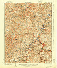
~ Philippi WV topo map, 1:62500 scale, 15 X 15 Minute, Historical, 1928, updated 1940
Philippi, West Virginia, USGS topographic map dated 1928.
Includes geographic coordinates (latitude and longitude). This topographic map is suitable for hiking, camping, and exploring, or framing it as a wall map.
Printed on-demand using high resolution imagery, on heavy weight and acid free paper, or alternatively on a variety of synthetic materials.
Topos available on paper, Waterproof, Poly, or Tyvek. Usually shipping rolled, unless combined with other folded maps in one order.
- Product Number: USGS-5415774
- Free digital map download (high-resolution, GeoPDF): Philippi, West Virginia (file size: 13 MB)
- Map Size: please refer to the dimensions of the GeoPDF map above
- Weight (paper map): ca. 55 grams
- Map Type: POD USGS Topographic Map
- Map Series: HTMC
- Map Verison: Historical
- Cell ID: 60949
- Scan ID: 253789
- Imprint Year: 1940
- Survey Year: 1902
- Datum: NAD
- Map Projection: Polyconic
- Map published by United States Geological Survey
- Map Language: English
- Scanner Resolution: 600 dpi
- Map Cell Name: Philippi
- Grid size: 15 X 15 Minute
- Date on map: 1928
- Map Scale: 1:62500
- Geographical region: West Virginia, United States
Neighboring Maps:
All neighboring USGS topo maps are available for sale online at a variety of scales.
Spatial coverage:
Topo map Philippi, West Virginia, covers the geographical area associated the following places:
- Kesling Mill - Galloway - Simons (historical) - Volga - Murphy - Boylen (historical) - Pecks Run - Mansfield - Wellington Heights - Audra - Teter - Middle Fork - Hopewell - Pepper - Berryburg - Carrollton - Adaland - Century Junction - Corder Crossing - Hodgesville - Tygart Glen - Elk City - Longview - Lillian (historical) - Midlan (historical) - Adma (historical) - Fox Hall (historical) - Meriden - Bear Mountain - Independence - Werner - Overfield - Pleasant Creek (historical) - Brownton - Five Forks - Astor - Mount Liberty - Swamp Run - Berryburg Junction - Union - Century - Boulder - Tygart Junction - Clements (historical) - Peeltree - Ruraldale - Philippi - O'Brien (historical)
- Map Area ID: AREA39.2539-80.25-80
- Northwest corner Lat/Long code: USGSNW39.25-80.25
- Northeast corner Lat/Long code: USGSNE39.25-80
- Southwest corner Lat/Long code: USGSSW39-80.25
- Southeast corner Lat/Long code: USGSSE39-80
- Northern map edge Latitude: 39.25
- Southern map edge Latitude: 39
- Western map edge Longitude: -80.25
- Eastern map edge Longitude: -80


