
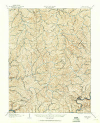
~ Otter WV topo map, 1:62500 scale, 15 X 15 Minute, Historical, 1906, updated 1961
Otter, West Virginia, USGS topographic map dated 1906.
Includes geographic coordinates (latitude and longitude). This topographic map is suitable for hiking, camping, and exploring, or framing it as a wall map.
Printed on-demand using high resolution imagery, on heavy weight and acid free paper, or alternatively on a variety of synthetic materials.
Topos available on paper, Waterproof, Poly, or Tyvek. Usually shipping rolled, unless combined with other folded maps in one order.
- Product Number: USGS-5415720
- Free digital map download (high-resolution, GeoPDF): Otter, West Virginia (file size: 12 MB)
- Map Size: please refer to the dimensions of the GeoPDF map above
- Weight (paper map): ca. 55 grams
- Map Type: POD USGS Topographic Map
- Map Series: HTMC
- Map Verison: Historical
- Cell ID: 60645
- Scan ID: 253762
- Imprint Year: 1961
- Survey Year: 1906
- Datum: NAD27
- Map Projection: Polyconic
- Map published by United States Geological Survey
- Map Language: English
- Scanner Resolution: 600 dpi
- Map Cell Name: Otter
- Grid size: 15 X 15 Minute
- Date on map: 1906
- Map Scale: 1:62500
- Geographical region: West Virginia, United States
Neighboring Maps:
All neighboring USGS topo maps are available for sale online at a variety of scales.
Spatial coverage:
Topo map Otter, West Virginia, covers the geographical area associated the following places:
- Douglas - Pigeon - Elana - Orma - Mudfork - Valley Fork - Linden - Kidtown - Barton (historical) - Bloomington (historical) - Stinson - Newton - Losie (historical) - Bright - Gould - Milo - Lydia - King - Nicut - Ovapa - Floe - Ivydale - Minnora - Chloe - Nebo - Little Italy - Uler - Euclid - Wallback - Rand (historical) - Walnut - Ossia - Whetstone - Oka - Dink - Big Otter - Gomez (historical)
- Map Area ID: AREA38.7538.5-81.25-81
- Northwest corner Lat/Long code: USGSNW38.75-81.25
- Northeast corner Lat/Long code: USGSNE38.75-81
- Southwest corner Lat/Long code: USGSSW38.5-81.25
- Southeast corner Lat/Long code: USGSSE38.5-81
- Northern map edge Latitude: 38.75
- Southern map edge Latitude: 38.5
- Western map edge Longitude: -81.25
- Eastern map edge Longitude: -81


