
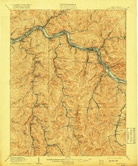
~ Montgomery WV topo map, 1:62500 scale, 15 X 15 Minute, Historical, 1910, updated 1918
Montgomery, West Virginia, USGS topographic map dated 1910.
Includes geographic coordinates (latitude and longitude). This topographic map is suitable for hiking, camping, and exploring, or framing it as a wall map.
Printed on-demand using high resolution imagery, on heavy weight and acid free paper, or alternatively on a variety of synthetic materials.
Topos available on paper, Waterproof, Poly, or Tyvek. Usually shipping rolled, unless combined with other folded maps in one order.
- Product Number: USGS-5415614
- Free digital map download (high-resolution, GeoPDF): Montgomery, West Virginia (file size: 12 MB)
- Map Size: please refer to the dimensions of the GeoPDF map above
- Weight (paper map): ca. 55 grams
- Map Type: POD USGS Topographic Map
- Map Series: HTMC
- Map Verison: Historical
- Cell ID: 57813
- Scan ID: 253704
- Imprint Year: 1918
- Survey Year: 1908
- Datum: Unstated
- Map Projection: Unstated
- Map published by United States Geological Survey
- Map Language: English
- Scanner Resolution: 600 dpi
- Map Cell Name: Montgomery
- Grid size: 15 X 15 Minute
- Date on map: 1910
- Map Scale: 1:62500
- Geographical region: West Virginia, United States
Neighboring Maps:
All neighboring USGS topo maps are available for sale online at a variety of scales.
Spatial coverage:
Topo map Montgomery, West Virginia, covers the geographical area associated the following places:
- Columbia - Montgomery Heights - Montgomery - Mahan - Dry Branch - Mount Carbon - Sharon - Red Warrior - Whittaker - Smithers - Gallagher - Burnwell - Nuckolls - Hugheston - Standard - Giles - East Bank - Coalburg - Ronda - Eagle - Glasgow - Hamilton - Alloy - Holly - Eskdale - Laing - London - Collinsdale - Republic - Quarrier - Decota - Leewood - Shrewsbury - Riverside - Page - Dawes - Ward - Miami - Elkridge - Chelyan - Kimberly - North Page - Pratt - Wevaco - Ohley - Carbondale - West Montgomery - Coalfield - Powellton - Deep Water - Cabin Creek - Hansford - Boomer - Cannelton - Crown Hill - Monarch - Longacre - Kincaid - Oakland - Carbon - Greencastle - Harewood - Cedar Grove - Acme - Kayford - McDunn - Handley - Crescent - Marting - Donwood - Hollygrove - Livingston
- Map Area ID: AREA38.2538-81.5-81.25
- Northwest corner Lat/Long code: USGSNW38.25-81.5
- Northeast corner Lat/Long code: USGSNE38.25-81.25
- Southwest corner Lat/Long code: USGSSW38-81.5
- Southeast corner Lat/Long code: USGSSE38-81.25
- Northern map edge Latitude: 38.25
- Southern map edge Latitude: 38
- Western map edge Longitude: -81.5
- Eastern map edge Longitude: -81.25


