
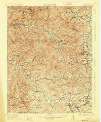
~ Eccles WV topo map, 1:62500 scale, 15 X 15 Minute, Historical, 1914, updated 1926
Eccles, West Virginia, USGS topographic map dated 1914.
Includes geographic coordinates (latitude and longitude). This topographic map is suitable for hiking, camping, and exploring, or framing it as a wall map.
Printed on-demand using high resolution imagery, on heavy weight and acid free paper, or alternatively on a variety of synthetic materials.
Topos available on paper, Waterproof, Poly, or Tyvek. Usually shipping rolled, unless combined with other folded maps in one order.
- Product Number: USGS-5415202
- Free digital map download (high-resolution, GeoPDF): Eccles, West Virginia (file size: 12 MB)
- Map Size: please refer to the dimensions of the GeoPDF map above
- Weight (paper map): ca. 55 grams
- Map Type: POD USGS Topographic Map
- Map Series: HTMC
- Map Verison: Historical
- Cell ID: 53713
- Scan ID: 253480
- Imprint Year: 1926
- Survey Year: 1911
- Datum: NAD
- Map Projection: Polyconic
- Map published by United States Geological Survey
- Map Language: English
- Scanner Resolution: 600 dpi
- Map Cell Name: Eccles
- Grid size: 15 X 15 Minute
- Date on map: 1914
- Map Scale: 1:62500
- Geographical region: West Virginia, United States
Neighboring Maps:
All neighboring USGS topo maps are available for sale online at a variety of scales.
Spatial coverage:
Topo map Eccles, West Virginia, covers the geographical area associated the following places:
- Surveyor - Eccles - Colcord - Lively - Dry Creek - Stover - Glen Daniel - Willis Branch - Bolt - Masseyville - Baylor (historical) - Glen White Junction (historical) - Naoma - Circle View - Emerson - Westerly - Metalton - Zada - Cirtsville - Dorothy - Long Branch - Posey - Roseville (historical) - Weirwood - Tolleys - Fairdale - Friendly View - Arnett - Milburn - Trap Hill - Clear Creek - Matville - East Kingston - Pax - Redbird - Ameagle - Rock Creek - Mossy - Saxon - Artie - Pineknob - United - Lick Fork - Shiloh - Dameron - Sweeneyburg - Harper - Kingston - Maynor
- Map Area ID: AREA3837.75-81.5-81.25
- Northwest corner Lat/Long code: USGSNW38-81.5
- Northeast corner Lat/Long code: USGSNE38-81.25
- Southwest corner Lat/Long code: USGSSW37.75-81.5
- Southeast corner Lat/Long code: USGSSE37.75-81.25
- Northern map edge Latitude: 38
- Southern map edge Latitude: 37.75
- Western map edge Longitude: -81.5
- Eastern map edge Longitude: -81.25


