
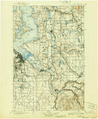
~ Tacoma WA topo map, 1:125000 scale, 30 X 30 Minute, Historical, 1900, updated 1940
Tacoma, Washington, USGS topographic map dated 1900.
Includes geographic coordinates (latitude and longitude). This topographic map is suitable for hiking, camping, and exploring, or framing it as a wall map.
Printed on-demand using high resolution imagery, on heavy weight and acid free paper, or alternatively on a variety of synthetic materials.
Topos available on paper, Waterproof, Poly, or Tyvek. Usually shipping rolled, unless combined with other folded maps in one order.
- Product Number: USGS-5411448
- Free digital map download (high-resolution, GeoPDF): Tacoma, Washington (file size: 9 MB)
- Map Size: please refer to the dimensions of the GeoPDF map above
- Weight (paper map): ca. 55 grams
- Map Type: POD USGS Topographic Map
- Map Series: HTMC
- Map Verison: Historical
- Cell ID: 66747
- Scan ID: 244185
- Imprint Year: 1940
- Survey Year: 1895
- Datum: Unstated
- Map Projection: Polyconic
- Map published by United States Geological Survey
- Map Language: English
- Scanner Resolution: 600 dpi
- Map Cell Name: Tacoma
- Grid size: 30 X 30 Minute
- Date on map: 1900
- Map Scale: 1:125000
- Geographical region: Washington, United States
Neighboring Maps:
All neighboring USGS topo maps are available for sale online at a variety of scales.
Spatial coverage:
Topo map Tacoma, Washington, covers the geographical area associated the following places:
- Highline - Orchard Grove - Silvercrest Mobile Home Park - Empire View Mobile Home Park - Portage - Rio Verde Mobile Estates - Rainier West Mobile Home Park - Town and Country Villa Mobile Home Park - Manzanita - Wilkeson - Cowley - Soos Creek Mobile Home Estates - Mountain View Estates Mobile Home Park - Meadowbrook Mobile Home Park - Evansville - Newaukum - Mileta - View Crest Mobile Manor - Pinecrest Mobile Home Park - College Place Mobile Home Park - Leisure Estates Mobile Home Park - Brookdale Greens Mobile Home Park - Cottonwood Mobile Home Park - Summer Villa Estates Mobile Home Park - Evergreen Manor Mobile Home Park - Skyway Mobile Home Park - Canyon View Mobile Home Park - Francis Mobile Home Court - Zenith - Laurelwood Valley Mobile Home Park - Boise - Noble - Wonderland Mobile Homes - Cedarbrook Mobile Home Park - Latona - Inglesea - Wynaco - The Firs Mobile Home Park - Ellisport - Maury - Cedarhurst - Valley View Mobile Home Park - Thomas - Shilo Mobile Home Park - Skylark Village II Mobile Home Park - Pleasant Valley Manor Mobile Home Park - Tanwax - Canyon Terrace Mobile Estates - Tyee Mobile Park - North West Mobile Home Park - Karwin Village Mobile Home Park - Pantera Lago Estates Mobile Home Park - Edgewood - Central Valley Mobile Home Park - Puyallup - Spring Valley Mobile Home Park - Woodmont Beach - Buckley - Fox Chase Mobile Home Park - Shawnee - South Hill Palisade Mobile Home Park - Midway - Kitts Corner - Maplewood Heights - Sunnyside Mobile Home Park - Berrydale - Belmor Mobile Home Park - Jovita - Puyallup River Junction - The River Mobile Estates - Hidden Glen Mobile Home Park - Auburn Green Mobile Home Park - Salishan - Dockton - Dorre Don - Shorewood - Kloshe Illahee Mobile Home Park - Quiet Meadows Mobile Park - Cedar Grove Mobile Home Park - Ponderosa Estates - Carbonado - Elliott - Sunnydale Mobile Home Park - Fruitland Gardens Mobile Home Park - Highlands Park - Tall Cedars Mobile Court - White River Estate Mobile Home Park - Benson Hill - Weller Martin Mobile Home Park - McMicken Heights - Viking Mobile Home Court - May Valley Manor Mobile Home Park - Meridian Terrace Mobile Manor - The Maples Mobile Home Park - Shady Hill Mobile Home Park - Manitou - O'Brien - Cedar View - Skyway - Willo Vista Mobile Estates
- Map Area ID: AREA47.547-122.5-122
- Northwest corner Lat/Long code: USGSNW47.5-122.5
- Northeast corner Lat/Long code: USGSNE47.5-122
- Southwest corner Lat/Long code: USGSSW47-122.5
- Southeast corner Lat/Long code: USGSSE47-122
- Northern map edge Latitude: 47.5
- Southern map edge Latitude: 47
- Western map edge Longitude: -122.5
- Eastern map edge Longitude: -122


