
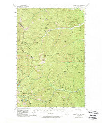
~ Cooper Gulch MT topo map, 1:62500 scale, 15 X 15 Minute, Historical, 1956, updated 1964
Cooper Gulch, Montana, USGS topographic map dated 1956.
Includes geographic coordinates (latitude and longitude). This topographic map is suitable for hiking, camping, and exploring, or framing it as a wall map.
Printed on-demand using high resolution imagery, on heavy weight and acid free paper, or alternatively on a variety of synthetic materials.
Topos available on paper, Waterproof, Poly, or Tyvek. Usually shipping rolled, unless combined with other folded maps in one order.
- Product Number: USGS-5400832
- Free digital map download (high-resolution, GeoPDF): Cooper Gulch, Montana (file size: 13 MB)
- Map Size: please refer to the dimensions of the GeoPDF map above
- Weight (paper map): ca. 55 grams
- Map Type: POD USGS Topographic Map
- Map Series: HTMC
- Map Verison: Historical
- Cell ID: 52898
- Scan ID: 267944
- Imprint Year: 1964
- Woodland Tint: Yes
- Aerial Photo Year: 1951
- Field Check Year: 1956
- Datum: NAD27
- Map Projection: Polyconic
- Map published by United States Geological Survey
- Map Language: English
- Scanner Resolution: 600 dpi
- Map Cell Name: Cooper Gulch
- Grid size: 15 X 15 Minute
- Date on map: 1956
- Map Scale: 1:62500
- Geographical region: Montana, United States
Neighboring Maps:
All neighboring USGS topo maps are available for sale online at a variety of scales.
Spatial coverage:
Topo map Cooper Gulch, Montana, covers the geographical area associated the following places:
- Lower Glidden Lake - Bug Creek - Cub Creek - Helwick Gulch - Montana Mine - Basin Creek - Sex Peak - Burnt Bridge Creek - Helwick Peak - Dirty Gulch - Demont Creek - Driveway Peak - Upper Fork Clear Creek - Green Gulch - Dixie Creek - Halfway House Historical SIte - Cooper Creek Mine - Chute Creek - Gilbert Gulch - Prospect Creek Mine - Jo Gulch - East Fork Crow Creek - Pear Lake - Arlington Mine - Jew Peak - Emma Creek - Cole Creek - Meadow Mountain/Tarbox Mine - Montana City (historical) - Beaver Lake - Duthie - Lost Branch - Lucky Boy Gulch - Shamrock Gulch - Montana Standard Mine - Saw Creek - Andys Knob - Dixie Peak - Bull Frog Mine - Lion Creek - Ripper Creek - Upper Glidden Lake - Stick Gulch - Lower Schwark Mine - Emma Peak Pack Trail - Everson Gulch - Emma Peak - West Fork Crow Creek - Black Creek - Sonju Mine - Iron Daisy Mine - Miller Gulch - Cat Creek - Reader Gulch Pack Trail - Sullivan Gulch - Dry Gulch - Twentythree Mile Creek - Larch Creek - Monroe Gulch - Haines Point - Cooper Gulch - Glidden Pass - Jack Pine Flats Campground - Evans Gulch - Sex Peak Lookout Station - Thompson Pass - Black Peak - Beaver Peak - Mountain House Historic Site - Antimony Creek - Haines Gulch - Twentyfour Mile Creek - Buster Brown Gulch - Skeeter Creek - Summit Creek - Anderson Gulch - Wheatgrass Gulch - Clear Peak - Cascade Gulch - North Fork Clear Creek - Looters Gulch - Antimony Mine - Foote Gulch - Evans Lake - Glidden Ridge - Haystack Mountain - South Branch Big Beaver Creek - Glidden Gulch - Daisy Creek - Mosquito Peak - Chipmunk Creek - Jack Waite Mine (historical) - Burson Gulch - Craik Airport - Quail Gulch - Woodchuck Creek - Dragin Creek - Blossom Lakes - Upper Schwark Mine - Cox Gulch
- Map Area ID: AREA47.7547.5-115.75-115.5
- Northwest corner Lat/Long code: USGSNW47.75-115.75
- Northeast corner Lat/Long code: USGSNE47.75-115.5
- Southwest corner Lat/Long code: USGSSW47.5-115.75
- Southeast corner Lat/Long code: USGSSE47.5-115.5
- Northern map edge Latitude: 47.75
- Southern map edge Latitude: 47.5
- Western map edge Longitude: -115.75
- Eastern map edge Longitude: -115.5


