
~ Wilmington DE topo map, 1:250000 scale, 1 X 2 Degree, Historical, 1966, updated 1975
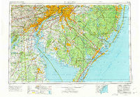
Wilmington, Delaware, USGS topographic map dated 1966.
Includes geographic coordinates (latitude and longitude). This topographic map is suitable for hiking, camping, and exploring, or framing it as a wall map.
Printed on-demand using high resolution imagery, on heavy weight and acid free paper, or alternatively on a variety of synthetic materials.
Topos available on paper, Waterproof, Poly, or Tyvek. Usually shipping rolled, unless combined with other folded maps in one order.
- Product Number: USGS-5390402
- Free digital map download (high-resolution, GeoPDF): Wilmington, Delaware (file size: 24 MB)
- Map Size: please refer to the dimensions of the GeoPDF map above
- Weight (paper map): ca. 55 grams
- Map Type: POD USGS Topographic Map
- Map Series: HTMC
- Map Verison: Historical
- Cell ID: 69102
- Scan ID: 255825
- Imprint Year: 1975
- Woodland Tint: Yes
- Aerial Photo Year: 1972
- Edit Year: 1972
- Field Check Year: 1966
- Datum: Unstated
- Map Projection: Transverse Mercator
- Map published by United States Army
- Map Language: English
- Scanner Resolution: 600 dpi
- Map Cell Name: Wilmington
- Grid size: 1 X 2 Degree
- Date on map: 1966
- Map Scale: 1:250000
- Geographical region: Delaware, United States
Neighboring Maps:
All neighboring USGS topo maps are available for sale online at a variety of scales.
Spatial coverage:
Topo map Wilmington, Delaware, covers the geographical area associated the following places:
- Murray Grove - Green Haven - Westover Hills - Rockdale - Pitman - Brandywine Hunt - Glasgow Court - Longview Farms - New Gretna - Ogletown - Forest Green Court - Jessups Mill - Woodbine Junction - East Lansdowne - Meadford Farms - Arbor Pointe Apartments - Dover East Estates Mobile Home Park - Rockland Village I and II - Ludlow - Magnolia - Star Hill - Alapocas - Victoria Wood - The Maples - Rogers Corners - Thorndale - Watsons Corner - Carmantown - West Collingswood Heights - Franklinville - Crowfoot - Forest Grove - Lindamere - Lacey - West Park - Claymont Heights - Packer Park - Beacon Hill - Penns Beach - Daniels Tract - Medford - Prices Corner - Runnymeade Farms - Blue Bell - Ivystone Farms - Academy Hills - Echelon - Franklin - Eden Park Gardens - Eder - Holly Oak Terrace - Gordy Estates - Devon - Ramblewood - Holly Knoll - Medford Lakes - The Village at Wild Quail - Birmingham Hunt - Chadds Ford - Reynard Crossing - Christiana - Highland Park - Windsor Hills - Winchester - Hamilton Park - Edgemoor - Burrs Mill - Dutton Mill - Voshell Cove - Lower Bank - Westview - Stones Throw - Forest Brook Glen - Fostertown - Winslow - Fox Chase - Dobbinsville - Bayside Beach - Lippincotts Corner - Windward - Moylan - Sherwood - Sugar Loaf Chase - Bayview Harbors - New Sharon - John Town - Richwood - Beach Haven Heights - Capitol Park - Glenside - Rodric Village - Palermo - Heatherbrooke - Leeds Point - Chester Heights - Barclay Farms - Glasgow Pines - Bridlebrook Estates - Dartmouth Woods II - Deerbrook I
- Map Area ID: AREA4039-76-74
- Northwest corner Lat/Long code: USGSNW40-76
- Northeast corner Lat/Long code: USGSNE40-74
- Southwest corner Lat/Long code: USGSSW39-76
- Southeast corner Lat/Long code: USGSSE39-74
- Northern map edge Latitude: 40
- Southern map edge Latitude: 39
- Western map edge Longitude: -76
- Eastern map edge Longitude: -74


