
~ Wilmington DE topo map, 1:250000 scale, 1 X 2 Degree, Historical, 1966, updated 1968
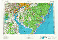
Wilmington, Delaware, USGS topographic map dated 1966.
Includes geographic coordinates (latitude and longitude). This topographic map is suitable for hiking, camping, and exploring, or framing it as a wall map.
Printed on-demand using high resolution imagery, on heavy weight and acid free paper, or alternatively on a variety of synthetic materials.
Topos available on paper, Waterproof, Poly, or Tyvek. Usually shipping rolled, unless combined with other folded maps in one order.
- Product Number: USGS-5390396
- Free digital map download (high-resolution, GeoPDF): Wilmington, Delaware (file size: 19 MB)
- Map Size: please refer to the dimensions of the GeoPDF map above
- Weight (paper map): ca. 55 grams
- Map Type: POD USGS Topographic Map
- Map Series: HTMC
- Map Verison: Historical
- Cell ID: 69102
- Scan ID: 255821
- Imprint Year: 1968
- Woodland Tint: Yes
- Field Check Year: 1966
- Datum: NAD27
- Map Projection: Universal Transverse Mercator
- Map published by United States Geological Survey
- Map Language: English
- Scanner Resolution: 600 dpi
- Map Cell Name: Wilmington
- Grid size: 1 X 2 Degree
- Date on map: 1966
- Map Scale: 1:250000
- Geographical region: Delaware, United States
Neighboring Maps:
All neighboring USGS topo maps are available for sale online at a variety of scales.
Spatial coverage:
Topo map Wilmington, Delaware, covers the geographical area associated the following places:
- Greens of Dover - Granite Farms Estates - Addingham - Parkridge at Bellevue - Gardendale - Four Seasons - Monterey Beach - Sunset Point - Riverdale Estates Mobile Home Park - Beach Haven Gardens - Wilmington - Royal Grant - Leiperville - Lum Estates - Wood Wards Addition - Baltimore Corner - Catalina Gardens - Hyllwynd - Mayetta - Nugentown - Eden Park Gardens - Milford Crossroads - Sherwood - Newport - Paris Villa - Olde Kensington - Bay Side - North Wildwood - Pebble Beach - Holiday Hills - Cobbs Mill - Welshire - Woodcrest - Franklin - Beach Haven Terrace - Holiday Beach - Mount Cuba - Rolling Hills - Ogden - Devon - Chelsea - Hickory Hill - Woodbrook - Goshen Crossing - Rosedale - Taylor Estates - Faulkland Woods - Revere Run - Saienni Farms - North Highlands Beach - Grand Oak Run - Masonville - Deer Run - Dobbinsville - Beades Estate - Crum Lynne - Meeting House Meadows - Dover Beaches South - Anglesey - Florence - Pembrey - Elk Forest - Elk Ranch Park - Slapes Corner - Westinghouse Village - Centre Grove - Pestletown - Reybold - Sheridan Square - Primos - Spring Garden - Estell Manor - Warwick - Blueball - Kent Acres - Concord Hunt - Hollingsworth Development - Lombard Acres - Berrytown - Pine Valley Farms - Buena - Wexford East - Yorklyn Ridge - Middletown - Porches Mill - Glen Cove - Elkview - Roselle Terrace - Bellevue Hills - Landisville - Caravel Farms - Shiloh - The Hills of Skyline - Silver Ridge - Cecilton Manor Mobile Home Park - Sconnelltown - Blackiston - Mallards Run - Brandywine Springs Manor - Steels Corner
- Map Area ID: AREA4039-76-74
- Northwest corner Lat/Long code: USGSNW40-76
- Northeast corner Lat/Long code: USGSNE40-74
- Southwest corner Lat/Long code: USGSSW39-76
- Southeast corner Lat/Long code: USGSSE39-74
- Northern map edge Latitude: 40
- Southern map edge Latitude: 39
- Western map edge Longitude: -76
- Eastern map edge Longitude: -74


