
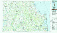
~ Seaford DE topo map, 1:100000 scale, 30 X 60 Minute, Historical, 1984, updated 1986
Seaford, Delaware, USGS topographic map dated 1984.
Includes geographic coordinates (latitude and longitude). This topographic map is suitable for hiking, camping, and exploring, or framing it as a wall map.
Printed on-demand using high resolution imagery, on heavy weight and acid free paper, or alternatively on a variety of synthetic materials.
Topos available on paper, Waterproof, Poly, or Tyvek. Usually shipping rolled, unless combined with other folded maps in one order.
- Product Number: USGS-5390380
- Free digital map download (high-resolution, GeoPDF): Seaford, Delaware (file size: 22 MB)
- Map Size: please refer to the dimensions of the GeoPDF map above
- Weight (paper map): ca. 55 grams
- Map Type: POD USGS Topographic Map
- Map Series: HTMC
- Map Verison: Historical
- Cell ID: 68336
- Scan ID: 255817
- Imprint Year: 1986
- Woodland Tint: Yes
- Aerial Photo Year: 1981
- Edit Year: 1984
- Datum: NAD27
- Map Projection: Universal Transverse Mercator
- Map published by United States Geological Survey
- Map Language: English
- Scanner Resolution: 600 dpi
- Map Cell Name: Seaford
- Grid size: 30 X 60 Minute
- Date on map: 1984
- Map Scale: 1:100000
- Geographical region: Delaware, United States
Neighboring Maps:
All neighboring USGS topo maps are available for sale online at a variety of scales.
Spatial coverage:
Topo map Seaford, Delaware, covers the geographical area associated the following places:
- Douglas Forge - Lloyd Landing - Tower Shores - Blackwater Village - Lake Forest Mobile Home Est - Whaleys Corners - White Oak Mobile Home Park - Dunbarton Oaks Apartments - Brick Wall Landing - Morris Mill - Oil City - Arabian Acres - Star Landing - Bowdens Garage (historical) - Sandy Brae - Federalsburg - Steele Acres - Indian Landing North Mobile Home Park - Homestead Mobile Home Park - Jones Crossroads - Ralph - Linchester - Mallard Point - Lowe - Piney Grove Estates - Waddells Corner - Belmont Acres - York Beach - Boyers Village - Highland Acres - Heronwood - Truitts Midway Development - Gravel Hill - Edgewood Manor - West Denton - Pepper - North Milford (historical) - Agner - New Market Village Mobile Home Park - Five Points - Six Forks - Bald Eagle Village - Airey - Pine Water Landing - Dagsboro - Asbury - Baileys Landing - Truitts Park - Legion Heights - Bryan Park - Byewood Manor - Rogers Haven - Chapel Woods - Holiday Pines - Shady Side - Linkwood - Three Seasons Mobile Home Park - Shady Dell Mobile Home Park - Waples - Israel Haul - Angola Crest Mobile Home Park - Farmington - Warwick Park - Redden - Dewey Beach - Hillsboro Estates - Newtons Acres - Nanticoke Shores Mobile Home Park - Prospect Hills - The Landing - Cool Spring Farms - Zoar - Miller Creek Park Mobile Home Park - Salem - New Market - Meadows - Broad Creek - Jacksons Ridge - Fairway Villas - Hickory Ridge - Rolph Landing - Evans Park Mobile Home Park - Fish Hook Mobile Home Court - Heritage Village - Reids Grove - Murrays Corner - D and K Mobile Home Park - Bloomfield Acres - Prince George Acres - Cross Keys - Atlanta Estates - Pine Water Farm - Club House Landing - Country Life Acres - Sloan Landing - Holly Hill - Shockley Manor - Providence - Whiteleysburg - Reliance
- Map Area ID: AREA3938.5-76-75
- Northwest corner Lat/Long code: USGSNW39-76
- Northeast corner Lat/Long code: USGSNE39-75
- Southwest corner Lat/Long code: USGSSW38.5-76
- Southeast corner Lat/Long code: USGSSE38.5-75
- Northern map edge Latitude: 39
- Southern map edge Latitude: 38.5
- Western map edge Longitude: -76
- Eastern map edge Longitude: -75


