
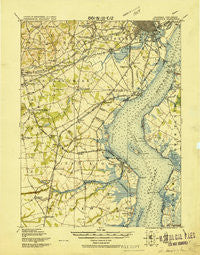
~ Wilmington DE topo map, 1:62500 scale, 15 X 15 Minute, Historical, 1919
Wilmington, Delaware, USGS topographic map dated 1919.
Includes geographic coordinates (latitude and longitude). This topographic map is suitable for hiking, camping, and exploring, or framing it as a wall map.
Printed on-demand using high resolution imagery, on heavy weight and acid free paper, or alternatively on a variety of synthetic materials.
Topos available on paper, Waterproof, Poly, or Tyvek. Usually shipping rolled, unless combined with other folded maps in one order.
- Product Number: USGS-5390372
- Free digital map download (high-resolution, GeoPDF): Wilmington, Delaware (file size: 9 MB)
- Map Size: please refer to the dimensions of the GeoPDF map above
- Weight (paper map): ca. 55 grams
- Map Type: POD USGS Topographic Map
- Map Series: HTMC
- Map Verison: Historical
- Cell ID: 64586
- Scan ID: 255802
- Woodland Tint: Yes
- Datum: Unstated
- Map Projection: Unstated
- Map published by United States Army Corps of Engineers
- Map Language: English
- Scanner Resolution: 600 dpi
- Map Cell Name: Wilmington
- Grid size: 15 X 15 Minute
- Date on map: 1919
- Map Scale: 1:62500
- Geographical region: Delaware, United States
Neighboring Maps:
All neighboring USGS topo maps are available for sale online at a variety of scales.
Spatial coverage:
Topo map Wilmington, Delaware, covers the geographical area associated the following places:
- Pendrew Manor - Eastburn Acres - Masonicville - Pencader Village - Kiamensi Heights - Lums Pond Estates II - Swanwyck Gardens - Woodshade - Sheridan Square - Maplecrest - Lindell Square - Newark Oaks - Farnhurst - Forest Park - Rolling Meadows - Pepper Ridge - Breezewood II - Cooper Farm - Mayview Manor - Brookbend - Biddles Corner - Iron Hills Apartments - Fox Chase Park - Stanton Estates - Harmony - Minquadale Trailer Village - Silverbrook Gardens - Carriage Run - Deer Run - Green Valley - Cedars Knoll - Concord Towers - Landlith - Albertson Park - Chelsea Estates - Garwood Estates - Harmony Hills - Raintree Village - Central Park - Cranston Heights - Lumbrook - Porter - Woodland - Lancaster Village - Red Mills Farms - Fairwinds - Landenberg Junction - Albertson - Boyds Corner - Duncan Village - Jefferson Farms - Wedgewood - Christiana - Clearview Manor - Catalina Gardens - Keeney - Faulkland Heights - Greenbridge - Duross Heights - The Bluffs - Washington Heights - Washington Park - The Pines of Pike Creek - Canby Park Estates - Mount Pleasant Mobile Home Park - Stony Crest - Glasgow - The Cedars - Woodcrest - Varlano - Becks Landing - Drummond North - Pleasant Hills - Windy Hills - Rolling Hills - Eden Park Gardens - Christiana Landing - Scottfield - Four Seasons Park - Swanwyck Estates - Linden Green Apartment - Milford Crossroads - New Castle - Salem Woods - Glendale - Marabou Meadows - Dragon Run Terrace Mobile Home Park - Corner Ketch - The Villa - Redmont - Wilmington - Manette Heights - Leedon Estates - Mermaid - Lindell Village - Brookmont Farms - Dunlinden Acres - Newark - Fox Woods - Swanwyck
- Map Area ID: AREA39.7539.5-75.75-75.5
- Northwest corner Lat/Long code: USGSNW39.75-75.75
- Northeast corner Lat/Long code: USGSNE39.75-75.5
- Southwest corner Lat/Long code: USGSSW39.5-75.75
- Southeast corner Lat/Long code: USGSSE39.5-75.5
- Northern map edge Latitude: 39.75
- Southern map edge Latitude: 39.5
- Western map edge Longitude: -75.75
- Eastern map edge Longitude: -75.5


