
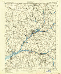
~ Seaford DE topo map, 1:62500 scale, 15 X 15 Minute, Historical, 1915, updated 1936
Seaford, Delaware, USGS topographic map dated 1915.
Includes geographic coordinates (latitude and longitude). This topographic map is suitable for hiking, camping, and exploring, or framing it as a wall map.
Printed on-demand using high resolution imagery, on heavy weight and acid free paper, or alternatively on a variety of synthetic materials.
Topos available on paper, Waterproof, Poly, or Tyvek. Usually shipping rolled, unless combined with other folded maps in one order.
- Product Number: USGS-5390358
- Free digital map download (high-resolution, GeoPDF): Seaford, Delaware (file size: 7 MB)
- Map Size: please refer to the dimensions of the GeoPDF map above
- Weight (paper map): ca. 55 grams
- Map Type: POD USGS Topographic Map
- Map Series: HTMC
- Map Verison: Historical
- Cell ID: 62227
- Scan ID: 255785
- Imprint Year: 1936
- Survey Year: 1912
- Datum: NAD
- Map Projection: Polyconic
- Map published by United States Geological Survey
- Map Language: English
- Scanner Resolution: 600 dpi
- Map Cell Name: Seaford
- Grid size: 15 X 15 Minute
- Date on map: 1915
- Map Scale: 1:62500
- Geographical region: Delaware, United States
Neighboring Maps:
All neighboring USGS topo maps are available for sale online at a variety of scales.
Spatial coverage:
Topo map Seaford, Delaware, covers the geographical area associated the following places:
- Records Estates - Patty Cannon Estates - Baileys Landing - Ricland Heights - Sussex Estates - Ruth Harbor - Millpond Acres - Bridgeville Manor - Meadow Acres - Friedel Property - Laurel Mobile Home Park - Portsville - Victor E Hurley Estates - Santo Domingo - River-view Acres - Atlanta - Douglas Forge - Pusey Development - Lakewood - North Seaford Heights - Fernwood - Riverton Acres - Cherrytree Landing - Bridgeville - Atlanta Estates - Jacobs Crossroads - Cannon - Hearns Crossroads - Fisher Mill Park - The Island - Nanticoke Acres - Lightfoots Furnace - Cantebury Apartments - Upcounty Mobile Home Park - Blades - Coverdale Crossroads - Briar Hook - Frederick Acres - Galestown - White River Estates - Old Furnace - Devonshire Woods - Colonial Acres - Middleford - Laurel Creek - Cooper Mill - Bethel - Seaford - Messick Development - Hurley Heights - Tussock Pond - Lowe - The Oaks - Concord - Shuffelt Acres - Matyiko Manor - Hollywoods Park - Reliance - Broad Creek - Seaford Heights - Oak Grove - Bossard Property - Lake Shores - Collins Mill Park - Laurel - Hastings Park Mobile Home Park - Nanticoke Estates - Kenmore Park - Snug Harbor - Branchview - Clarksons Crossroads - Johnson Development - Sandy Fork - Ralphs - Craigs Mill - Hickman Village Estates Mobile Home Park - Lake Pines - Shady Acres Mobile Home Park - Lakeside Manor - Scottsdale Park Mobile Home Park - North Shores Addition - Beaver Dam Heights - Ross - Bryan Park - Sharptown - Dogwood Acres - Wooded Acres - Richard Heights - Hoagland Subdivision - Waterview Acres - Mobile Gardens Mobile Home Park - Hill N Dale - Heritage Village - Old Mill Acres - North Shores - Broad Acres - Hearns Mill - Midnight Thicket - Meadows - Broad Creek Estates
- Map Area ID: AREA38.7538.5-75.75-75.5
- Northwest corner Lat/Long code: USGSNW38.75-75.75
- Northeast corner Lat/Long code: USGSNE38.75-75.5
- Southwest corner Lat/Long code: USGSSW38.5-75.75
- Southeast corner Lat/Long code: USGSSE38.5-75.5
- Northern map edge Latitude: 38.75
- Southern map edge Latitude: 38.5
- Western map edge Longitude: -75.75
- Eastern map edge Longitude: -75.5


