
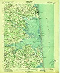
~ Rehoboth DE topo map, 1:62500 scale, 15 X 15 Minute, Historical, 1918
Rehoboth, Delaware, USGS topographic map dated 1918.
Includes geographic coordinates (latitude and longitude). This topographic map is suitable for hiking, camping, and exploring, or framing it as a wall map.
Printed on-demand using high resolution imagery, on heavy weight and acid free paper, or alternatively on a variety of synthetic materials.
Topos available on paper, Waterproof, Poly, or Tyvek. Usually shipping rolled, unless combined with other folded maps in one order.
- Product Number: USGS-5390334
- Free digital map download (high-resolution, GeoPDF): Rehoboth, Delaware (file size: 7 MB)
- Map Size: please refer to the dimensions of the GeoPDF map above
- Weight (paper map): ca. 55 grams
- Map Type: POD USGS Topographic Map
- Map Series: HTMC
- Map Verison: Historical
- Cell ID: 61545
- Scan ID: 255770
- Woodland Tint: Yes
- Survey Year: 1917
- Datum: Unstated
- Map Projection: Unstated
- Map published by United States Geological Survey
- Map published by United States Army Corps of Engineers
- Map published by United States Department of War
- Map Language: English
- Scanner Resolution: 600 dpi
- Map Cell Name: Rehoboth
- Grid size: 15 X 15 Minute
- Date on map: 1918
- Map Scale: 1:62500
- Geographical region: Delaware, United States
Neighboring Maps:
All neighboring USGS topo maps are available for sale online at a variety of scales.
Spatial coverage:
Topo map Rehoboth, Delaware, covers the geographical area associated the following places:
- West Rehoboth - Marshtown - Silver View Farm - Enchanted Acres Mobile Home Park - Pine Water Landing - Irons Lane Landing - Lingo Estate Mobile Home Park - Midway Estates - Fox Run Mobile Home Park - Long Neck Village Mobile Home Park - Shockley Manor - Green Briar Court - Pots Nets North Mobile Home Park - Sandy Brae - Byewood Manor - Cedar Shores - West Beach - Cool Spring - Leisure Point Mobile Home Park - Angola Landing - Holly Pines Mobile Home Park - Mastens Heights Mobile Home Park - Aspen Meadows - Blackwater Beach - Strawberry Landing - Driftwood Village Mobile Home Park - Denton Woods Mobile Home Park - Silver Lake Shores - Arabian Acres - Belltown - The Landing - Collins Creek Estates - Riverdale - Indian Beach - Bullseye - Banks Development - Fox Hollow - Henlopen Acres - Gull Point - York Beach - Lynn Lee Village Mobile Home Park - Truitts Midway Development - Five Points - Rogers Haven - Hidden Acres - Holiday Pines - Sussex Shores - Boyers Village - Bay View Park - Collins Park Mobile Home Park - Robinson Landing - Tuckahoe Acres - Henlopen Keys - Omar - Danfield Acres - Angola Beach Mobile Home Park - Cuelen Acres - Bay Vista - Old Landing - Old Landing Woods - Long Neck - Sandy Landing - The Plantations - Sea Spray Village - Lingo Landing - Herring Landing - Thatchers Landing - The Reservation - Cedarville Mobile Home Park - Pine Water Farm - Tower Shores - Hollymount - Banks Harbor Estates - Sea Farers Village - Nanticoke Shores Mobile Home Park - Spring Lake - Beachfield - Shady Dell Mobile Home Park - Blackwater Cove - Ocean Village - Pond Acres - Hillcrest Acres Mobile Home Park - Bald Eagle Village - Midway - William Ritter Manor - Bank Harbor Retreat - Sea Colony - Massey Landing - Killens Addition - Orchard Manor - Sea Air Mobile Home Park - Steele Acres - Midway Park - Pinetown - Silver Lake Manor - Buck Hill Landing - Ben Robins Landing - North Shores - Shockley Heights - Sea Colony East
- Map Area ID: AREA38.7538.5-75.25-75
- Northwest corner Lat/Long code: USGSNW38.75-75.25
- Northeast corner Lat/Long code: USGSNE38.75-75
- Southwest corner Lat/Long code: USGSSW38.5-75.25
- Southeast corner Lat/Long code: USGSSE38.5-75
- Northern map edge Latitude: 38.75
- Southern map edge Latitude: 38.5
- Western map edge Longitude: -75.25
- Eastern map edge Longitude: -75


