
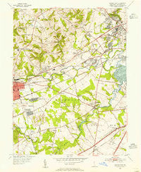
~ Newark East DE topo map, 1:24000 scale, 7.5 X 7.5 Minute, Historical, 1953, updated 1955
Newark East, Delaware, USGS topographic map dated 1953.
Includes geographic coordinates (latitude and longitude). This topographic map is suitable for hiking, camping, and exploring, or framing it as a wall map.
Printed on-demand using high resolution imagery, on heavy weight and acid free paper, or alternatively on a variety of synthetic materials.
Topos available on paper, Waterproof, Poly, or Tyvek. Usually shipping rolled, unless combined with other folded maps in one order.
- Product Number: USGS-5390150
- Free digital map download (high-resolution, GeoPDF): Newark East, Delaware (file size: 13 MB)
- Map Size: please refer to the dimensions of the GeoPDF map above
- Weight (paper map): ca. 55 grams
- Map Type: POD USGS Topographic Map
- Map Series: HTMC
- Map Verison: Historical
- Cell ID: 31899
- Scan ID: 255625
- Imprint Year: 1955
- Woodland Tint: Yes
- Aerial Photo Year: 1951
- Field Check Year: 1953
- Datum: NAD27
- Map Projection: Polyconic
- Map published by United States Geological Survey
- Map Language: English
- Scanner Resolution: 600 dpi
- Map Cell Name: Newark East
- Grid size: 7.5 X 7.5 Minute
- Date on map: 1953
- Map Scale: 1:24000
- Geographical region: Delaware, United States
Neighboring Maps:
All neighboring USGS topo maps are available for sale online at a variety of scales.
Spatial coverage:
Topo map Newark East, Delaware, covers the geographical area associated the following places:
- Birchwood Park - Bear - Newkirk Estates - Lindell Village - Catalina Gardens - Christiana Landing - Weatherhill Farms - Hillside Heights - Jamestowne - Skyline Crest - Rolling Hills - Pinecrest - Linden Green Apartment - Chapel Hill - Brandywine Springs - Milford Meadows - Linden Heath - Duncan Glen - Greenbridge - Milford Crossroads - Raintree Village - Pencader Village - Monterey Farms - Pleasant Hill - Sheridan Square - Heritage Farms - Piermont Woods - Yorkshire - Cedar Farms - Salem Village - Kiamensi Heights - Duncan Woods - Cooper Farm - Washington Heights - Albertson - Deacons Walk - Concord Towers - Stratford - Cherokee Woods - Deer Run - Newark Oaks - Peikin Park - Red Mills Farms - Lumbrook - Albion - Eastburn Farms - Ogletown - Harmony - Christiana - Delpark Manor - Redmont - Linden Hill - Iron Hills Apartments - Brookhaven - Birch Pointe - Foxfire - Cedars - Wellington Woods - Brookmont Farms - Westfield - Mermaid Run - Glendale - The Bluffs - Newark - Meadowood - Arundel - Scottfield - The Villa - The Village of Drummond Hill - Pine Swamp Corner - Ivy Ridge - English Village - Limestone Gap - Limestone Acres - Woodcreek - Wilson - Cedars Knoll - Lindell Square - Choate - Elmwood - Centennial Village - Pendrew Manor - The Cedars - Beechers Lot - Brandywine Springs Manor - Montclare - Milltown - Faulkland Heights - Woodshade - Green Valley - Coach Hill - Marshallton - Capital Trail Farms - Linden Square - Brookside - Grendon Farms - Carriage Run - Belford Manor - Christiana Village - Fairway Falls
- Map Area ID: AREA39.7539.625-75.75-75.625
- Northwest corner Lat/Long code: USGSNW39.75-75.75
- Northeast corner Lat/Long code: USGSNE39.75-75.625
- Southwest corner Lat/Long code: USGSSW39.625-75.75
- Southeast corner Lat/Long code: USGSSE39.625-75.625
- Northern map edge Latitude: 39.75
- Southern map edge Latitude: 39.625
- Western map edge Longitude: -75.75
- Eastern map edge Longitude: -75.625


