
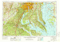
~ Washington DC topo map, 1:250000 scale, 1 X 2 Degree, Historical, 1957, updated 1976
Washington, District of Columbia, USGS topographic map dated 1957.
Includes geographic coordinates (latitude and longitude). This topographic map is suitable for hiking, camping, and exploring, or framing it as a wall map.
Printed on-demand using high resolution imagery, on heavy weight and acid free paper, or alternatively on a variety of synthetic materials.
Topos available on paper, Waterproof, Poly, or Tyvek. Usually shipping rolled, unless combined with other folded maps in one order.
- Product Number: USGS-5389872
- Free digital map download (high-resolution, GeoPDF): Washington, District of Columbia (file size: 24 MB)
- Map Size: please refer to the dimensions of the GeoPDF map above
- Weight (paper map): ca. 55 grams
- Map Type: POD USGS Topographic Map
- Map Series: HTMC
- Map Verison: Historical
- Cell ID: 69087
- Scan ID: 257790
- Imprint Year: 1976
- Woodland Tint: Yes
- Aerial Photo Year: 1952
- Edit Year: 1969
- Field Check Year: 1957
- Datum: Unstated
- Map Projection: Transverse Mercator
- Map published by United States Geological Survey
- Map Language: English
- Scanner Resolution: 600 dpi
- Map Cell Name: Washington
- Grid size: 1 X 2 Degree
- Date on map: 1957
- Map Scale: 1:250000
- Geographical region: District of Columbia, United States
Neighboring Maps:
All neighboring USGS topo maps are available for sale online at a variety of scales.
Spatial coverage:
Topo map Washington, District of Columbia, covers the geographical area associated the following places:
- Barstow - Cheston - Garfield Heights - Peach Blossom Farm - Spotsylvania - Indian Town - High Bridge Estates - Sunset - Mosley Acres - Edsall Park - Mosby Woods - Holly Acres - Walnut Grove - Hunting Neck Woods - Gunston Manor - White Landing - Ramoth - South Fairlington - Ardmore - Sun Valley Estates - Chewnings Corner - Masons Beach - Wittman - Twinbrook Estates - Fines Corner - Saint Johns Creek - Oldfield - Delight - Neavitt - Hickory Thicket - Landview Estates - Tacketts Mill - Willow Woods - Columbia Pines - Bay Country - Chopawamsic (historical) - Fernwood Mobile Home Park - Parklawn - Country Club Hills - Marumsco Woods - Joseph Sullivan Estates - Classic Shore - Reo Vista Plaza - Hillsmere Shores - Morgansburg - Dogue - Stanards Mill - Saint Stephens - Freedom Village - Lower Marlboro Towne - Swinks Mill - Cedar Heights - North Cleveland Park - Bristow - Fox Hill - Sunset Manor - Canterbury Village - Battery Ridge Estates - Jennie Run Estates - Mill Creek - Rose Haven - Woodridge - Loveville Acres - Anchorage - Andover Estates - Clover Hill - Highpointe - Baie Holm - Knotsmythes Landing - Howard - Townes of Ashleigh - Thomas Circle - Pine View Estates - Autumn Estates - Snug Harbor - Halfway - Heather Hills - Glassmanor - Parkland - Tyler Heights - Fairfax Woods - Harbor View - Birkwood Estates - Glenbrook - Bryantown - Harbor Light Beach - Marlow Heights - Queen Anne Knolls - Farrs Corner - Timber Creek - Chevy Chase Heights - Chestnut Hill - Charowood - Clarendon - German - Estates of Brooke - Springvale - Lakota - Sherwood Forest - River Terrace
- Map Area ID: AREA3938-78-76
- Northwest corner Lat/Long code: USGSNW39-78
- Northeast corner Lat/Long code: USGSNE39-76
- Southwest corner Lat/Long code: USGSSW38-78
- Southeast corner Lat/Long code: USGSSE38-76
- Northern map edge Latitude: 39
- Southern map edge Latitude: 38
- Western map edge Longitude: -78
- Eastern map edge Longitude: -76


