
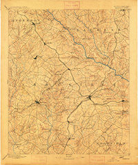
~ Abbeville SC topo map, 1:125000 scale, 30 X 30 Minute, Historical, 1892, updated 1913
Abbeville, South Carolina, USGS topographic map dated 1892.
Includes geographic coordinates (latitude and longitude). This topographic map is suitable for hiking, camping, and exploring, or framing it as a wall map.
Printed on-demand using high resolution imagery, on heavy weight and acid free paper, or alternatively on a variety of synthetic materials.
Topos available on paper, Waterproof, Poly, or Tyvek. Usually shipping rolled, unless combined with other folded maps in one order.
- Product Number: USGS-5389108
- Free digital map download (high-resolution, GeoPDF): Abbeville, South Carolina (file size: 7 MB)
- Map Size: please refer to the dimensions of the GeoPDF map above
- Weight (paper map): ca. 55 grams
- Map Type: POD USGS Topographic Map
- Map Series: HTMC
- Map Verison: Historical
- Cell ID: 64840
- Scan ID: 262024
- Imprint Year: 1913
- Survey Year: 1890
- Datum: Unstated
- Map Projection: Unstated
- Map published by United States Geological Survey
- Map Language: English
- Scanner Resolution: 600 dpi
- Map Cell Name: Abbeville
- Grid size: 30 X 30 Minute
- Date on map: 1892
- Map Scale: 1:125000
- Geographical region: South Carolina, United States
Neighboring Maps:
All neighboring USGS topo maps are available for sale online at a variety of scales.
Spatial coverage:
Topo map Abbeville, South Carolina, covers the geographical area associated the following places:
- Pinehurst - Druid Hills - Shoals Junction - Emerald Place - Dann (historical) - Foxville Crossroads - Westgate - Dominicks (historical) - Pine Grove Hills - Avondale - Kirksey - Roman Acres - Parkwood - Sharon - Jones (historical) - Owens (historical) - Greenwood - Cedar Lake - Irby - Ware Shoals - Honea Path - Fawn Brook - Central-Shiloh - Blakedale - Sand Ridge - Millers Mill - Fairs Crossroads - Salak - Millers Grove (historical) - Gaines Crossroads - Callison - Woodlawn - Clatworthy Crossroads - Panola Village - Aspen Heights - Bethiah - Rushville - Cokesbury - Brick House - Hartzog Acres - Waterloo - Winona - Keowee - Shiloh - North Hills Estates - Maddens - Buck Stand - Bradley Corner - Lorenzo (historical) - Coronaca - Verdery - Locksley Hall - Bethel - Harris - Isle of Pines - Baldwin - Mount Gallagher - Epworth - Smithville - Northfall Acres - Black - Lakewood Heights - Hill and Dale - Cothran (historical) - Ekom - Iris - Breckridge - Canterbury - Bradley - Irvines Landing - Mount Olive - Hyde Park - Collins Lakeside Village - High Point - Lodge Grounds - Harris Springs - The Hook (historical) - Wisewood - Laurens - Forest Hills - Vermillion - Belle Meade - Highland Forest - Forest Lake - Crosby (historical) - Wade Heights - Lota - Glendale - Smithfield - Simpson (historical) - Murray (historical) - Augusta Fields - Brewerton - Erie (historical) - Mathews Village - Raintree - Stalnaker Heights - Chinquapin - Broadmouth - Fairforest
- Map Area ID: AREA34.534-82.5-82
- Northwest corner Lat/Long code: USGSNW34.5-82.5
- Northeast corner Lat/Long code: USGSNE34.5-82
- Southwest corner Lat/Long code: USGSSW34-82.5
- Southeast corner Lat/Long code: USGSSE34-82
- Northern map edge Latitude: 34.5
- Southern map edge Latitude: 34
- Western map edge Longitude: -82.5
- Eastern map edge Longitude: -82


