
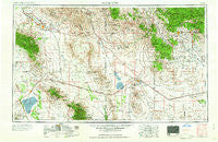
~ Silver City NM topo map, 1:250000 scale, 1 X 2 Degree, Historical, 1958
Silver City, New Mexico, USGS topographic map dated 1958.
Includes geographic coordinates (latitude and longitude). This topographic map is suitable for hiking, camping, and exploring, or framing it as a wall map.
Printed on-demand using high resolution imagery, on heavy weight and acid free paper, or alternatively on a variety of synthetic materials.
Topos available on paper, Waterproof, Poly, or Tyvek. Usually shipping rolled, unless combined with other folded maps in one order.
- Product Number: USGS-5386532
- Free digital map download (high-resolution, GeoPDF): Silver City, New Mexico (file size: 19 MB)
- Map Size: please refer to the dimensions of the GeoPDF map above
- Weight (paper map): ca. 55 grams
- Map Type: POD USGS Topographic Map
- Map Series: HTMC
- Map Verison: Historical
- Cell ID: 69031
- Scan ID: 193070
- Woodland Tint: Yes
- Aerial Photo Year: 1950
- Field Check Year: 1954
- Datum: Unstated
- Map Projection: Transverse Mercator
- Map published by United States Geological Survey
- Map Language: English
- Scanner Resolution: 600 dpi
- Map Cell Name: Silver City
- Grid size: 1 X 2 Degree
- Date on map: 1958
- Map Scale: 1:250000
- Geographical region: New Mexico, United States
Neighboring Maps:
All neighboring USGS topo maps are available for sale online at a variety of scales.
Spatial coverage:
Topo map Silver City, New Mexico, covers the geographical area associated the following places:
- Turkey Flat - McGhee Wells - Whitlock Cienega - Bonita - Separ - York - Pima - Duncan - Masons Mill (historical) - Fierro - Steins - McKelvey Place - Hext Place - Virden - Oak Grove - Artesia - Sid Place - Redstone - Wimsattville - Sheldon - Hanover - Vanar - Turnerville - Cobre - Cotton City - Lisbon - Leitendorf (historical) - Riverside - Olga - Luzena - Hurley - Newton (historical) - Ulmoris - Central - Old Columbine - Matthew Place - Little Walnut Village - Maques Place - Aragon Place - Silver City - Little Franks - White Signal - Safford - Solomon - Steeplerock (historical) - Gila - Safford Ranch Mobile Home Park - Gripe - Raso - Bowie - East Camp (historical) - Fox - Yellow Hammer Mill - Union Hill - Manzoro - Brockman - Buena Vista - Taylor Place - Daily Estates Mobile Home Park - Lexington Pines Mobile Home Park - Black Hawk (historical) - Valley View Mobile Home and Recreational Vehicle Park - Edgal Place - Mangas Springs - Vanadium - Kansas Settlement - Sunrise Village Mobile Home Park - Fort Bayard - San Jose - Pinos Altos - Gold Hill (historical) - Valedon - Guthrie - Graham - Central - Hanover Junction - Willcox - Ivanhoe (historical) - Mondel - Buckeye Mill - Hollywood - Cedar Grove (historical) - Santa Clara - San Simon - Guess Place - Sanchez - Alhambra (historical) - Tyrone - Red Lamp Mobile Home Park - Telegraph (historical) - Dos Cabezas - Ashurst - Whitewater - Mitchell Place - Gary - Three Way - Wheeler Place - Estes Place - Bryce - Bayard
- Map Area ID: AREA3332-110-108
- Northwest corner Lat/Long code: USGSNW33-110
- Northeast corner Lat/Long code: USGSNE33-108
- Southwest corner Lat/Long code: USGSSW32-110
- Southeast corner Lat/Long code: USGSSE32-108
- Northern map edge Latitude: 33
- Southern map edge Latitude: 32
- Western map edge Longitude: -110
- Eastern map edge Longitude: -108


