
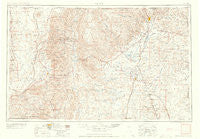
~ Raton NM topo map, 1:250000 scale, 1 X 2 Degree, Historical, 1958
Raton, New Mexico, USGS topographic map dated 1958.
Includes geographic coordinates (latitude and longitude). This topographic map is suitable for hiking, camping, and exploring, or framing it as a wall map.
Printed on-demand using high resolution imagery, on heavy weight and acid free paper, or alternatively on a variety of synthetic materials.
Topos available on paper, Waterproof, Poly, or Tyvek. Usually shipping rolled, unless combined with other folded maps in one order.
- Product Number: USGS-5386494
- Free digital map download (high-resolution, GeoPDF): Raton, New Mexico (file size: 13 MB)
- Map Size: please refer to the dimensions of the GeoPDF map above
- Weight (paper map): ca. 55 grams
- Map Type: POD USGS Topographic Map
- Map Series: HTMC
- Map Verison: Historical
- Cell ID: 68984
- Scan ID: 403180
- Visual Version Number: 2
- Aerial Photo Year: 1954
- Field Check Year: 1954
- Datum: Unstated
- Map Projection: Transverse Mercator
- Map published by United States Geological Survey
- Map Language: English
- Scanner Resolution: 508 dpi
- Map Cell Name: Raton
- Grid size: 1 X 2 Degree
- Date on map: 1958
- Map Scale: 1:250000
- Geographical region: New Mexico, United States
Neighboring Maps:
All neighboring USGS topo maps are available for sale online at a variety of scales.
Spatial coverage:
Topo map Raton, New Mexico, covers the geographical area associated the following places:
- Taos Ski Valley - McDaniel Cimarron Place - Toril - Vallecito - Halls Peak (historical) - Chimayo - Canova - Holman - Solo - Pilar - Rio Pueblo - Miami - Los LeFebres - Truchas - Servilleta - La Cienaga - Eagle Nest - French - Elizabethtown - Midnight (historical) - Buena Vista - Trampas - Moly - Sunshine Valley - Taos - Taylor Springs - Rodarte - Sunny Side - Capitan Hill - Hebron - Ocate - Lakeview Pines - Cañoncito - Brilliant - Ventero - Carson - Carisbrook - Angel Fire - Llano - La Belle (historical) - Anchor (historical) - Rio Chiquito - Dillon - Nolan (historical) - Yankee - Shuree - Shady Brook - Ojo Sarco - Colfax - Cordova - Vadito - Twining - Taos Junction - Lucero - Embudo - Angostura - El Prado - Tinaja - Cañoncito - Vallecitos - La Cuestecita - Black Lake Resorts - Black Lake - Abbott - La Bolsa - Los Cocas - Montecito - Agua Fria - La Jara - Wagon Mound - Perryville (historical) - Llano Largo - Levy - Koehler - Questa - McGreggor Place - Chico - La Junta - Llano Quemado - Talpa - Urraca Place - Ojito - Apodaca - Casa Grande - Schomberg - Sugarite - No Agua - Los Cordovas - Angostura - McCrystal Place - Cañon - Ring Place - Barranca - Lama - Raton - Rio Lucio - Tres Piedras - Valdez - Naranjos - Keota
- Map Area ID: AREA3736-106-104
- Northwest corner Lat/Long code: USGSNW37-106
- Northeast corner Lat/Long code: USGSNE37-104
- Southwest corner Lat/Long code: USGSSW36-106
- Southeast corner Lat/Long code: USGSSE36-104
- Northern map edge Latitude: 37
- Southern map edge Latitude: 36
- Western map edge Longitude: -106
- Eastern map edge Longitude: -104


