
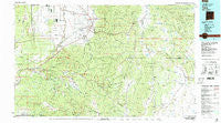
~ Taos NM topo map, 1:100000 scale, 30 X 60 Minute, Historical, 1983, updated 1986
Taos, New Mexico, USGS topographic map dated 1983.
Includes geographic coordinates (latitude and longitude). This topographic map is suitable for hiking, camping, and exploring, or framing it as a wall map.
Printed on-demand using high resolution imagery, on heavy weight and acid free paper, or alternatively on a variety of synthetic materials.
Topos available on paper, Waterproof, Poly, or Tyvek. Usually shipping rolled, unless combined with other folded maps in one order.
- Product Number: USGS-5386168
- Free digital map download (high-resolution, GeoPDF): Taos, New Mexico (file size: 28 MB)
- Map Size: please refer to the dimensions of the GeoPDF map above
- Weight (paper map): ca. 55 grams
- Map Type: POD USGS Topographic Map
- Map Series: HTMC
- Map Verison: Historical
- Cell ID: 68438
- Scan ID: 194535
- Imprint Year: 1986
- Woodland Tint: Yes
- Aerial Photo Year: 1979
- Edit Year: 1983
- Datum: NAD27
- Map Projection: Universal Transverse Mercator
- Map published by United States Geological Survey
- Map Language: English
- Scanner Resolution: 600 dpi
- Map Cell Name: Taos
- Grid size: 30 X 60 Minute
- Date on map: 1983
- Map Scale: 1:100000
- Geographical region: New Mexico, United States
Neighboring Maps:
All neighboring USGS topo maps are available for sale online at a variety of scales.
Spatial coverage:
Topo map Taos, New Mexico, covers the geographical area associated the following places:
- Ocate - Angostura - Angostura - Cañoncito - Los LeFebres - Rio Pueblo - Carson - Truchas - Pilar - Cañon - Solo - Velarde - Ranchos de Taos - Chimayo - Agua Fria - Black Lake - Tres Ritos - Llano Quemado - Rio Lucio - Barranca - El Prado - Vallecitos - Montecito - El Valle - La Cuestecita - Taos Pueblo - Ojito - La Junta - Lucero - La Cienaga - Pot Creek - Las Mochas - Chacon - Ojo Feliz - Los Cisneros - Vallecito - Picuris Pueblo - Cordova - Taos - Embudo - Los Medinas - Rock Wall - Black Lake Resorts - Rinconada - La Jara - Trampas - Taos Junction - Dixon - Apodaca - Los Huerros - Llano Largo - Halls Peak (historical) - Rodarte - Llano - Chamisal - Los Cordovas - Ojo Sarco - Peñasco - Sipapu - Canova - La Bolsa - Holman - Shady Brook - Vadito - Angel Fire - Guadalupita - Los Cocas - El Turquillo - Talpa - Los Pachecos - Ranchito - Rio Chiquito - Valle Escondido
- Map Area ID: AREA36.536-106-105
- Northwest corner Lat/Long code: USGSNW36.5-106
- Northeast corner Lat/Long code: USGSNE36.5-105
- Southwest corner Lat/Long code: USGSSW36-106
- Southeast corner Lat/Long code: USGSSE36-105
- Northern map edge Latitude: 36.5
- Southern map edge Latitude: 36
- Western map edge Longitude: -106
- Eastern map edge Longitude: -105


