
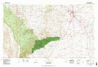
~ Carlsbad NM topo map, 1:100000 scale, 30 X 60 Minute, Historical, 1979, updated 1979
Carlsbad, New Mexico, USGS topographic map dated 1979.
Includes geographic coordinates (latitude and longitude). This topographic map is suitable for hiking, camping, and exploring, or framing it as a wall map.
Printed on-demand using high resolution imagery, on heavy weight and acid free paper, or alternatively on a variety of synthetic materials.
Topos available on paper, Waterproof, Poly, or Tyvek. Usually shipping rolled, unless combined with other folded maps in one order.
- Product Number: USGS-5386072
- Free digital map download (high-resolution, GeoPDF): Carlsbad, New Mexico (file size: 27 MB)
- Map Size: please refer to the dimensions of the GeoPDF map above
- Weight (paper map): ca. 55 grams
- Map Type: POD USGS Topographic Map
- Map Series: HTMC
- Map Verison: Historical
- Cell ID: 67238
- Scan ID: 190040
- Imprint Year: 1979
- Woodland Tint: Yes
- Visual Version Number: 1
- Aerial Photo Year: 1975
- Edit Year: 1979
- Datum: NAD27
- Map Projection: Universal Transverse Mercator
- Map published by United States Geological Survey
- Map Language: English
- Scanner Resolution: 600 dpi
- Map Cell Name: Carlsbad
- Grid size: 30 X 60 Minute
- Date on map: 1979
- Map Scale: 1:100000
- Geographical region: New Mexico, United States
Neighboring Maps:
All neighboring USGS topo maps are available for sale online at a variety of scales.
Spatial coverage:
Topo map Carlsbad, New Mexico, covers the geographical area associated the following places:
- Queen - La Huerta - Black River Village - Three Forks - Lookout (historical) - Barber Crossing - Otis - Harkey Crossing - Hagerman Heights - Four Forks - Four Wells - Whites City - Malaga - Carlsbad - Harroun Crossing - Lookout Crossing - West Carlsbad - Loving - Avalon - Red Bluff - San Jose
- Map Area ID: AREA32.532-105-104
- Northwest corner Lat/Long code: USGSNW32.5-105
- Northeast corner Lat/Long code: USGSNE32.5-104
- Southwest corner Lat/Long code: USGSSW32-105
- Southeast corner Lat/Long code: USGSSE32-104
- Northern map edge Latitude: 32.5
- Southern map edge Latitude: 32
- Western map edge Longitude: -105
- Eastern map edge Longitude: -104


