
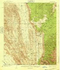
~ El Paso Gap NM topo map, 1:62500 scale, 15 X 15 Minute, Historical, 1940
El Paso Gap, New Mexico, USGS topographic map dated 1940.
Includes geographic coordinates (latitude and longitude). This topographic map is suitable for hiking, camping, and exploring, or framing it as a wall map.
Printed on-demand using high resolution imagery, on heavy weight and acid free paper, or alternatively on a variety of synthetic materials.
Topos available on paper, Waterproof, Poly, or Tyvek. Usually shipping rolled, unless combined with other folded maps in one order.
- Product Number: USGS-5385554
- Free digital map download (high-resolution, GeoPDF): El Paso Gap, New Mexico (file size: 10 MB)
- Map Size: please refer to the dimensions of the GeoPDF map above
- Weight (paper map): ca. 55 grams
- Map Type: POD USGS Topographic Map
- Map Series: HTMC
- Map Verison: Historical
- Cell ID: 53771
- Scan ID: 190528
- Woodland Tint: Yes
- Survey Year: 1935
- Datum: NAD27
- Map Projection: Polyconic
- Map published by United States Geological Survey
- Map Language: English
- Scanner Resolution: 600 dpi
- Map Cell Name: El Paso Gap
- Grid size: 15 X 15 Minute
- Date on map: 1940
- Map Scale: 1:62500
- Geographical region: New Mexico, United States
Neighboring Maps:
All neighboring USGS topo maps are available for sale online at a variety of scales.
Spatial coverage:
Topo map El Paso Gap, New Mexico, covers the geographical area associated the following places:
- Berlin Tank - X Bar Tank - Pasqual Tank - Soldier Spring - Salt Basin - Big Ridge - Middleton Storage Tank - Trick Tank - Black River Water Storage - Hog Spring - Upper McKittrick Canyon Research Natural Area - Keller Tank - Black River Spring - Effendale Tank - Game Department Cabin - Poor House - Pine Canyon - Coats Water Storage Tank - Panorama Peak - McCollum Ranch - Shattuck Valley - La Paloma Tank - Stone Canyon - Knee Deep - White Mule Ridge - Buck Tank - Box Tank - Polk Tank - Hepler Ranch - Rough Canyon - Devils Den Spring - Shattuck Well - Brokeoff Mountains Wilderness Study Area - Locklear Water Storage Tank - El Paso Gap Church - Devils Den Canyon - South Tank Canyon - Anderson Tank - Helper Tank - Manzanita Ridge - Guadalupe Tank - Number Two Canyon - Lee Magby Tank - Arch Lewis Tank - JRC Spring - Locklear Tank - La Paloma Canyon - Monzarita Tank - Cistern Canyon - Irabarne Water Storage Tank - Cork Draw - Polk Water Storage Tank - Camp Wilderness Ridge - Lower Irabane Tank - Hamm Well - Hamm Tank - Trail Canyon - Jackson Tank - West Water Storage Tank - Middle Dog Canyon - Hamm Storage Tank - Dutch Tank - Plowman Tank - Hughes Ranch - Pickett Tanks - Calf Canyon - Hamm Draw - Kuykendal Tank - Rock Tank - Kingston Canyon - Dirt Tank - Upper Dog Canyon - Black Lake - Road Tank - Hollan Tank - Martine Ridge - Panther Canyon - Plowman Peak - Guadalupe Escarpment Wilderness Study Area - Panther Tank - Andrus and Golf Ranch - North Well - O Bar U Waterhole - Owens Tank - South Tank - Sixshooter Canyon - Fir Canyon - El Paso Gap - Wildcat Draw - Big Boy Tank - Stone Water Storage Tank - Helper Ranch - Middle Canyon - Middleton Well - Bradley Tank - Coats Lake - Den Well - Brister Tank - Wildcat Canyon - Lewis Tank
- Map Area ID: AREA32.2532-105-104.75
- Northwest corner Lat/Long code: USGSNW32.25-105
- Northeast corner Lat/Long code: USGSNE32.25-104.75
- Southwest corner Lat/Long code: USGSSW32-105
- Southeast corner Lat/Long code: USGSSE32-104.75
- Northern map edge Latitude: 32.25
- Southern map edge Latitude: 32
- Western map edge Longitude: -105
- Eastern map edge Longitude: -104.75


