
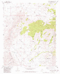
~ Godfrey Peak NM topo map, 1:24000 scale, 7.5 X 7.5 Minute, Historical, 1982, updated 1982
Godfrey Peak, New Mexico, USGS topographic map dated 1982.
Includes geographic coordinates (latitude and longitude). This topographic map is suitable for hiking, camping, and exploring, or framing it as a wall map.
Printed on-demand using high resolution imagery, on heavy weight and acid free paper, or alternatively on a variety of synthetic materials.
Topos available on paper, Waterproof, Poly, or Tyvek. Usually shipping rolled, unless combined with other folded maps in one order.
- Product Number: USGS-5380414
- Free digital map download (high-resolution, GeoPDF): Godfrey Peak, New Mexico (file size: 10 MB)
- Map Size: please refer to the dimensions of the GeoPDF map above
- Weight (paper map): ca. 55 grams
- Map Type: POD USGS Topographic Map
- Map Series: HTMC
- Map Verison: Historical
- Cell ID: 17561
- Scan ID: 190783
- Imprint Year: 1982
- Woodland Tint: Yes
- Aerial Photo Year: 1972
- Edit Year: 1982
- Field Check Year: 1975
- Datum: NAD27
- Map Projection: Transverse Mercator
- Map published by United States Geological Survey
- Map Language: English
- Scanner Resolution: 600 dpi
- Map Cell Name: Godfrey Peak
- Grid size: 7.5 X 7.5 Minute
- Date on map: 1982
- Map Scale: 1:24000
- Geographical region: New Mexico, United States
Neighboring Maps:
All neighboring USGS topo maps are available for sale online at a variety of scales.
Spatial coverage:
Topo map Godfrey Peak, New Mexico, covers the geographical area associated the following places:
- Buck Pasture Spring - Robinson Spring - Rock House Spring - Candelaria Spring - Gamble Canyon - Rose Peak - Padilla Spring - Gamble Windmill - Crawford Well - Barber Ridge - Tanner Canyon - Daugherty Spring - Coal Mine Tank - Brownfield Spring - Snaggletooth Well - Crawford Canyon - Elder Canyon - Halfway Windmill - Godfrey Peak - Mc Iver Canyon - Lincoln Spring - Winston Canyon - Brownfield Canyon - Twin Wells Windmill - Walker Windmill - Maverick Spring - Rocky Point Spring - Robinson Canyon - Goat Canyon - Tanner Spring - Trinidad Spring - North Windmill - Three Rivers Ranch - Tramble Windmill - I Bar X Spring - Snaggletooth - Bessie Case Spring - Hall Windmill - Candelaria Canyon - Brush Canyon - Lincoln Canyon - I-X Ranch - New Brownfield Well - Hide Spring - Rattlesnake Canyon - Daugherty Ridge - Wingfield Spring - Godfrey Hills - Three Rivers Campground - Cottonwood Spring - Bataan Lodge - Brownfield Windmill - Winston Spring
- Map Area ID: AREA33.533.375-106-105.875
- Northwest corner Lat/Long code: USGSNW33.5-106
- Northeast corner Lat/Long code: USGSNE33.5-105.875
- Southwest corner Lat/Long code: USGSSW33.375-106
- Southeast corner Lat/Long code: USGSSE33.375-105.875
- Northern map edge Latitude: 33.5
- Southern map edge Latitude: 33.375
- Western map edge Longitude: -106
- Eastern map edge Longitude: -105.875


