
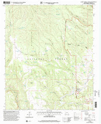
~ Burnt Corral Canyon NM topo map, 1:24000 scale, 7.5 X 7.5 Minute, Historical, 1999, updated 2002
Burnt Corral Canyon, New Mexico, USGS topographic map dated 1999.
Includes geographic coordinates (latitude and longitude). This topographic map is suitable for hiking, camping, and exploring, or framing it as a wall map.
Printed on-demand using high resolution imagery, on heavy weight and acid free paper, or alternatively on a variety of synthetic materials.
Topos available on paper, Waterproof, Poly, or Tyvek. Usually shipping rolled, unless combined with other folded maps in one order.
- Product Number: USGS-5378592
- Free digital map download (high-resolution, GeoPDF): Burnt Corral Canyon, New Mexico (file size: 11 MB)
- Map Size: please refer to the dimensions of the GeoPDF map above
- Weight (paper map): ca. 55 grams
- Map Type: POD USGS Topographic Map
- Map Series: HTMC
- Map Verison: Historical
- Cell ID: 6341
- Scan ID: 193870
- Imprint Year: 2002
- Woodland Tint: Yes
- Aerial Photo Year: 1996
- Edit Year: 2000
- Datum: NAD27
- Map Projection: Transverse Mercator
- Map published by United States Forest Service
- Map Language: English
- Scanner Resolution: 600 dpi
- Map Cell Name: Burnt Corral Canyon
- Grid size: 7.5 X 7.5 Minute
- Date on map: 1999
- Map Scale: 1:24000
- Geographical region: New Mexico, United States
Neighboring Maps:
All neighboring USGS topo maps are available for sale online at a variety of scales.
Spatial coverage:
Topo map Burnt Corral Canyon, New Mexico, covers the geographical area associated the following places:
- Corner Tank - Jordan Tank - Windfall Canyon - Burnt Corral - Maverick Tank Number Two - Burnt Corral Tank - Tommy Hill Canyon - Cement Tank - Fork Tank - Mattice Tank - Bobcat Spring - John Tank - Snafi Tank - TJ Tank - Burnt Corral Canyon - Whiterocks - Trail End Ranch - Preacher Tank - North Tank - Juniper Tank - Substitute Tank - XSX Corral - Adobe Spring - Diamond Creek - Malpais Tank - Adobe Tank - Windfall Tanks - DD-Antelope Tank - Antelope Tank - Middle Fork Tank - Montoya Homestead (historical) - Maverick Tank - Rock Bottom Tank - Whiterocks Tanks - Mahogany Tank - Fall Spring - Black Mountain Tank - House Spring - Windfall Tank Number Two - North Mesa - Trap Spring - East Jordan Tank - Windfall Mesa Well - CCC Tank - No Permit Tank - Adobe Canyon - Cement Canyon - Tommy Hill Tank - Antelope Corral - Headquarters Spring - Windfall Tank
- Map Area ID: AREA33.37533.25-108.25-108.125
- Northwest corner Lat/Long code: USGSNW33.375-108.25
- Northeast corner Lat/Long code: USGSNE33.375-108.125
- Southwest corner Lat/Long code: USGSSW33.25-108.25
- Southeast corner Lat/Long code: USGSSE33.25-108.125
- Northern map edge Latitude: 33.375
- Southern map edge Latitude: 33.25
- Western map edge Longitude: -108.25
- Eastern map edge Longitude: -108.125


