
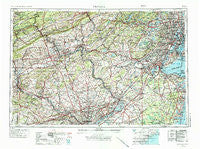
~ Newark NJ topo map, 1:250000 scale, 1 X 2 Degree, Historical, 1944, updated 1986
Newark, New Jersey, USGS topographic map dated 1944.
Includes geographic coordinates (latitude and longitude). This topographic map is suitable for hiking, camping, and exploring, or framing it as a wall map.
Printed on-demand using high resolution imagery, on heavy weight and acid free paper, or alternatively on a variety of synthetic materials.
Topos available on paper, Waterproof, Poly, or Tyvek. Usually shipping rolled, unless combined with other folded maps in one order.
- Product Number: USGS-5377654
- Free digital map download (high-resolution, GeoPDF): Newark, New Jersey (file size: 26 MB)
- Map Size: please refer to the dimensions of the GeoPDF map above
- Weight (paper map): ca. 55 grams
- Map Type: POD USGS Topographic Map
- Map Series: HTMC
- Map Verison: Historical
- Cell ID: 68933
- Scan ID: 255462
- Imprint Year: 1986
- Woodland Tint: Yes
- Photo Revision Year: 1969
- Aerial Photo Year: 1944
- Edit Year: 1969
- Datum: Unstated
- Map Projection: Transverse Mercator
- Map published by United States Geological Survey
- Map Language: English
- Scanner Resolution: 600 dpi
- Map Cell Name: Newark
- Grid size: 1 X 2 Degree
- Date on map: 1944
- Map Scale: 1:250000
- Geographical region: New Jersey, United States
Neighboring Maps:
All neighboring USGS topo maps are available for sale online at a variety of scales.
Spatial coverage:
Topo map Newark, New Jersey, covers the geographical area associated the following places:
- Seipstown - Ager Tract - Treyburn - Nutley - Centennial Station - Almont - East Allentown - Penllyn Knoll - Jacksonburg - Locust Manor - Harneys Corner - Imlaystown - Salem Hill - Audubon Gardens - Blair Mill Village West - New Milford - Five Points - Matawan - Liberty Corner - Whittier Oaks - Snyders - River View Park - Cooperstown - Coldspring Crossing - Isabella - Orchard Glen - Reevytown - Ashfield - Mont Clare - Providence Ridge - Carpenter - Logansville - Diebertsville - Jeddo - Linconia - Evansburg - Linvale - Sassamansville - Copella - Mercerville - Wingspread - Seven Stars - Exeter Village - Moonachie - Lehigh Furnace - Factoryville - Silvertown (historical) - Slykerville - Teterboro - Ivygreene Run - Kratz - South Easton - Pilgerts - Cheesequake - Jarrettown - Weatherly - Pine Swamp - Juniper Circle - Glenfield - Lakewood - Summerdale - Mile Hollow - Harrison - State Hill - Ewing - De La Salle - Chesterbrook - Berwick Place - Woodrow - Madison Park - Barley Lane - Greater Cross Roads - Kenhorst - Wyomissing Park - Churchville - Schoolside Manor - Garden - Filetown - Patricks Corners - Packerton Junction - Sharper - Elkins Park Gardens - Pleasant View Lake - High Bridge - Readington - Pleasantville - Robeson Crossing - Strafford - New Village - Berkley - Limerick Village Mobile Home Park - Eckley - Harrity - Salfordville - Souderton - Cloverly Farms - Vernoy - New Hope - Kennedy House - Bartley
- Map Area ID: AREA4140-76-74
- Northwest corner Lat/Long code: USGSNW41-76
- Northeast corner Lat/Long code: USGSNE41-74
- Southwest corner Lat/Long code: USGSSW40-76
- Southeast corner Lat/Long code: USGSSE40-74
- Northern map edge Latitude: 41
- Southern map edge Latitude: 40
- Western map edge Longitude: -76
- Eastern map edge Longitude: -74


