
~ Newark NJ topo map, 1:250000 scale, 1 X 2 Degree, Historical, 1944, updated 1974
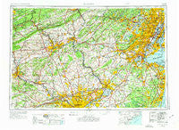
Newark, New Jersey, USGS topographic map dated 1944.
Includes geographic coordinates (latitude and longitude). This topographic map is suitable for hiking, camping, and exploring, or framing it as a wall map.
Printed on-demand using high resolution imagery, on heavy weight and acid free paper, or alternatively on a variety of synthetic materials.
Topos available on paper, Waterproof, Poly, or Tyvek. Usually shipping rolled, unless combined with other folded maps in one order.
- Product Number: USGS-5377652
- Free digital map download (high-resolution, GeoPDF): Newark, New Jersey (file size: 24 MB)
- Map Size: please refer to the dimensions of the GeoPDF map above
- Weight (paper map): ca. 55 grams
- Map Type: POD USGS Topographic Map
- Map Series: HTMC
- Map Verison: Historical
- Cell ID: 68933
- Scan ID: 255461
- Imprint Year: 1974
- Woodland Tint: Yes
- Visual Version Number: 2
- Photo Revision Year: 1969
- Aerial Photo Year: 1944
- Edit Year: 1969
- Datum: Unstated
- Map Projection: Transverse Mercator
- Map published by United States Geological Survey
- Map Language: English
- Scanner Resolution: 600 dpi
- Map Cell Name: Newark
- Grid size: 1 X 2 Degree
- Date on map: 1944
- Map Scale: 1:250000
- Geographical region: New Jersey, United States
Neighboring Maps:
All neighboring USGS topo maps are available for sale online at a variety of scales.
Spatial coverage:
Topo map Newark, New Jersey, covers the geographical area associated the following places:
- Leopard Farms - Rydal Estates - Reading - Birch Hills - Mill Run - Paoli Manor - Crabtree Hollow - Washington Crossing - Norriton East - Rismiller - Highlands at Wyomissing - Penn Valley - Jeffersonville - Mountain Village Mobile Home Park - Browns Mill - Meadowbrook - New Bedford - Jamesville - Grist Mill Farms - Hamilton Square - Weavertown - Whippany - Clifton - Middletown - Renninger Tract - Grenoble - Wister Woods - Scobeyville - Collingwood Park - Martins Beach - Tierneys Corner - Millers - Bloomfield - Planebrook - Centerville - Spruce Run - Oxford Village - Fergusonville - Cherry Hill - Mermaid - Sykesville - Rocky Hill - Monmouth Junction - Voorhees Corner - Tresckow - Middletown - Providence Green - Unionville - Village Scene Trailer Park - Prallsville - Milford Park - Freemanville - Ampere - East Oak Lane - Fox Chase - Glenlake - Worcester - Penn Haven Junction - The Mermont - Ivygreene Run - Wilburtha - Trappe Meadows - Pleasant Grove - Buckmanville - Bloomingdale - Inglewood - Thornridge - Afton - Wynnewood House - Greenville - Logansville - Knechts - Hill Crest - Heebnerville - Ramseysburg - Cooks Mills - Baltusrol - Hughes Park - Morgan - Wrightstown - Eastwick - Millburn - Little Gap - Red Hook Houses - Coffeetown - Cherokee Ranch - Applegarth - Trenton - Hudson Heights - Springside - Rockville - The Woods at Providence Reserve - Dale - Ashbourne - Cornwells Manor - Bechtelsville - Crestmont Farms - Bath Addition - Lower Longswamp - Waynesborough Woods
- Map Area ID: AREA4140-76-74
- Northwest corner Lat/Long code: USGSNW41-76
- Northeast corner Lat/Long code: USGSNE41-74
- Southwest corner Lat/Long code: USGSSW40-76
- Southeast corner Lat/Long code: USGSSE40-74
- Northern map edge Latitude: 41
- Southern map edge Latitude: 40
- Western map edge Longitude: -76
- Eastern map edge Longitude: -74


