
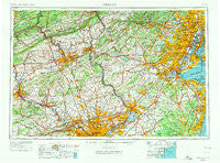
~ Newark NJ topo map, 1:250000 scale, 1 X 2 Degree, Historical, 1944, updated 1971
Newark, New Jersey, USGS topographic map dated 1944.
Includes geographic coordinates (latitude and longitude). This topographic map is suitable for hiking, camping, and exploring, or framing it as a wall map.
Printed on-demand using high resolution imagery, on heavy weight and acid free paper, or alternatively on a variety of synthetic materials.
Topos available on paper, Waterproof, Poly, or Tyvek. Usually shipping rolled, unless combined with other folded maps in one order.
- Product Number: USGS-5377648
- Free digital map download (high-resolution, GeoPDF): Newark, New Jersey (file size: 22 MB)
- Map Size: please refer to the dimensions of the GeoPDF map above
- Weight (paper map): ca. 55 grams
- Map Type: POD USGS Topographic Map
- Map Series: HTMC
- Map Verison: Historical
- Cell ID: 68933
- Scan ID: 255459
- Imprint Year: 1971
- Woodland Tint: Yes
- Photo Revision Year: 1969
- Aerial Photo Year: 1944
- Edit Year: 1969
- Datum: Unstated
- Map Projection: Transverse Mercator
- Map published by United States Geological Survey
- Map Language: English
- Scanner Resolution: 600 dpi
- Map Cell Name: Newark
- Grid size: 1 X 2 Degree
- Date on map: 1944
- Map Scale: 1:250000
- Geographical region: New Jersey, United States
Neighboring Maps:
All neighboring USGS topo maps are available for sale online at a variety of scales.
Spatial coverage:
Topo map Newark, New Jersey, covers the geographical area associated the following places:
- Hamilton Court - Schlemville - Guthriesville - Parkland Heights - Ridgeview Terrace Trailer Park - Carpenter - East Bangor - Ashbourne - Cottageville - Wayne - Southard - Garfield Park East - Vanguard Mobile Home Park - Seagate - Miller Manor - Sandy Ridge - Joanna Furnace - Continental Arms - Hidden Springs Mobile Home Park - Earle - Lancasterville - Bradevelt - Dublin Hunt II - Hoffmans - Scarlets Mill - Paoli Road - Pineview Estates - Cedar Grove - Millstone - Shamrock Station - Pine Acres - Pleasant Plains - Weissport - Longmead Farms - Beaufort - Moselem - South Hermitage - Five Locks - Golf View Manor - Woodport - Mount Penn - Bath Junction - Mumbauersville - Lamington - Hokendauqua - Chimney Rock - Natco - Upper Emilie - Narrowsville - Lewisville - Dogs Corners - Marlin Hills - Titusville - Sand Brook - Trout Creek - Mickleys - Fairview Park - Eatontown - Union Square - Wetherills Corner - Hillcrest - Ridgefield Park - Smiths Corner - Glendale - Long Lane Farms III - Grovers Mill - Willborne Acres - Lower Valley - Glenlake - Mansfield - Bellview - Spinnerstown - Drakes Creek - Yocum Estates - Summer Chase - Oley - Ernston - Mountain Park - Green Village - Troy Hills - Roseland - Irvington - Saucon - Ancient Oaks - Hill Crest - Carteret - Cedar Knolls - Coopersville - Applegarth - Williamstown - Alsace Manor - Mosserville - Coopersburg - Westover Club - Kulpsville - Drifton - Morristown - Crabtree Hollow - Westgate Hills - Benson East
- Map Area ID: AREA4140-76-74
- Northwest corner Lat/Long code: USGSNW41-76
- Northeast corner Lat/Long code: USGSNE41-74
- Southwest corner Lat/Long code: USGSSW40-76
- Southeast corner Lat/Long code: USGSSE40-74
- Northern map edge Latitude: 41
- Southern map edge Latitude: 40
- Western map edge Longitude: -76
- Eastern map edge Longitude: -74


