
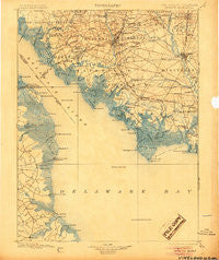
~ Vineland NJ topo map, 1:125000 scale, 30 X 30 Minute, Historical, 1899, updated 1905
Vineland, New Jersey, USGS topographic map dated 1899.
Includes geographic coordinates (latitude and longitude). This topographic map is suitable for hiking, camping, and exploring, or framing it as a wall map.
Printed on-demand using high resolution imagery, on heavy weight and acid free paper, or alternatively on a variety of synthetic materials.
Topos available on paper, Waterproof, Poly, or Tyvek. Usually shipping rolled, unless combined with other folded maps in one order.
- Product Number: USGS-5377638
- Free digital map download (high-resolution, GeoPDF): Vineland, New Jersey (file size: 7 MB)
- Map Size: please refer to the dimensions of the GeoPDF map above
- Weight (paper map): ca. 55 grams
- Map Type: POD USGS Topographic Map
- Map Series: HTMC
- Map Verison: Historical
- Cell ID: 66858
- Scan ID: 255454
- Imprint Year: 1905
- Survey Year: 1896
- Datum: Unstated
- Map Projection: Unstated
- Map published by United States Geological Survey
- Map Language: English
- Scanner Resolution: 600 dpi
- Map Cell Name: Vineland
- Grid size: 30 X 30 Minute
- Date on map: 1899
- Map Scale: 1:125000
- Geographical region: New Jersey, United States
Neighboring Maps:
All neighboring USGS topo maps are available for sale online at a variety of scales.
Spatial coverage:
Topo map Vineland, New Jersey, covers the geographical area associated the following places:
- Shadybrook Farms - Rammel Mill - Magnolia - Misty Pines - High Point Mobile Home Park - Bridgeton - Haleyville - Newport Landing - Tindells Landing - Othello - Harmersville - Oak Grove - Fordville - Maurice River - Kitts Hummock - Woodland Beach - Baileytown - Frenchs Mobile Homes - Clarks Mill - Generals Green - Bivalve - Orchard Center - Cowgills Corner - Kernan Corner - Laurel Lake - Lummistown - Sheppards Mill - Bridgeton Junction - New England Crossroads - Bay Side - Carmel - Jericho - Whitehall Landing - Brookhaven Estates - Finley - Wickham Woods - Bowers Beach - Harmony - New Italy - Generals Greene - Fairton - Husted Landing - Roosevelt Park - Locustville - Loyds Corner - Dragston - Big Oak - Carlls Corner - Mickles Mill - Watsons Corner - Grandview Meadows - Port Mahon - Cypress Gardens - Gandys Beach - Port Norris - Norma - Farmingdale - Vineland - Dover East Estates Mobile Home Park - Garrison Corner - Hunters Ridge - Shell Pile - Dividing Creek - Millville - Woodruff - Shiloh - Warren Landing - Webb Landing - Lores Mill - Willis Corner - Shaws Mill - Greenwich - Laffertys Corner - Bayview Heights - Brookdale Heights - Frederica - Turkey Point Corner - Barkers Landing - Oak Shadows - Fortescue - Magnolia Mobile Home Park - Doverbrook Gardens - South Bowers - George Meyers Development - Dickerson Corner - Bowers Landing - Pine Island - Little Heaven - Bowentown - Sea Breeze - Centre Grove - Buckshutem - Seeley - Church Creek - Gum Tree Corner - Maskells Mill - Clayville - Schepps Valley - Garton - Florence
- Map Area ID: AREA39.539-75.5-75
- Northwest corner Lat/Long code: USGSNW39.5-75.5
- Northeast corner Lat/Long code: USGSNE39.5-75
- Southwest corner Lat/Long code: USGSSW39-75.5
- Southeast corner Lat/Long code: USGSSE39-75
- Northern map edge Latitude: 39.5
- Southern map edge Latitude: 39
- Western map edge Longitude: -75.5
- Eastern map edge Longitude: -75


