
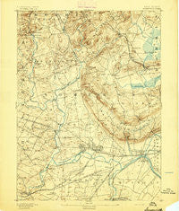
~ Somerville NJ topo map, 1:62500 scale, 15 X 15 Minute, Historical, 1893
Somerville, New Jersey, USGS topographic map dated 1893.
Includes geographic coordinates (latitude and longitude). This topographic map is suitable for hiking, camping, and exploring, or framing it as a wall map.
Printed on-demand using high resolution imagery, on heavy weight and acid free paper, or alternatively on a variety of synthetic materials.
Topos available on paper, Waterproof, Poly, or Tyvek. Usually shipping rolled, unless combined with other folded maps in one order.
- Product Number: USGS-5377552
- Free digital map download (high-resolution, GeoPDF): Somerville, New Jersey (file size: 9 MB)
- Map Size: please refer to the dimensions of the GeoPDF map above
- Weight (paper map): ca. 55 grams
- Map Type: POD USGS Topographic Map
- Map Series: HTMC
- Map Verison: Historical
- Cell ID: 62767
- Scan ID: 255381
- Survey Year: 1886
- Datum: Unstated
- Map Projection: Unstated
- Map published by United States Geological Survey
- Map Language: English
- Scanner Resolution: 600 dpi
- Map Cell Name: Somerville
- Grid size: 15 X 15 Minute
- Date on map: 1893
- Map Scale: 1:62500
- Geographical region: New Jersey, United States
Neighboring Maps:
All neighboring USGS topo maps are available for sale online at a variety of scales.
Spatial coverage:
Topo map Somerville, New Jersey, covers the geographical area associated the following places:
- Burnt Mills - Ukrainian Village - Round Top - Davis Bridge - Neshanic Station - South Bound Brook - Bradley Gardens - Bound Brook Junction - Gladstone - Liberty Corner - Lyons - Osborn Mills - Mount Horeb - Woods Tavern - Pottersville - Branchburg Park - Raritan - Pill Hill - Somerville - Pluckemin - Weston - Chimney Rock - Peapack - East Millstone - Hamilton - Finderne - South Branch - Martinsville - Manville - Whitehouse - Pleasant Valley - Springdale - Bedminster - Royce Valley - Sutton (historical) - Basking Ridge - Somersetin - Mount Bethel - Fieldville - Readington - Madisonville - Milltown - Mine Brook - Coontown - North Branch Depot - Lamington - Grandview - Far Hills - Logansville - Bound Brook - Vliettown - Greater Cross Roads - South Somerville (historical) - North Branch - Van Dorans Mills - Millington - Green Knoll - Oldwick - Flagtown - Zarephath - Bernardsville - Blaziers Corner - Frankfort
- Map Area ID: AREA40.7540.5-74.75-74.5
- Northwest corner Lat/Long code: USGSNW40.75-74.75
- Northeast corner Lat/Long code: USGSNE40.75-74.5
- Southwest corner Lat/Long code: USGSSW40.5-74.75
- Southeast corner Lat/Long code: USGSSE40.5-74.5
- Northern map edge Latitude: 40.75
- Southern map edge Latitude: 40.5
- Western map edge Longitude: -74.75
- Eastern map edge Longitude: -74.5


