
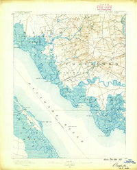
~ Bay Side NJ topo map, 1:62500 scale, 15 X 15 Minute, Historical, 1890
Bay Side, New Jersey, USGS topographic map dated 1890.
Includes geographic coordinates (latitude and longitude). This topographic map is suitable for hiking, camping, and exploring, or framing it as a wall map.
Printed on-demand using high resolution imagery, on heavy weight and acid free paper, or alternatively on a variety of synthetic materials.
Topos available on paper, Waterproof, Poly, or Tyvek. Usually shipping rolled, unless combined with other folded maps in one order.
- Product Number: USGS-5377078
- Free digital map download (high-resolution, GeoPDF): Bay Side, New Jersey (file size: 8 MB)
- Map Size: please refer to the dimensions of the GeoPDF map above
- Weight (paper map): ca. 55 grams
- Map Type: POD USGS Topographic Map
- Map Series: HTMC
- Map Verison: Historical
- Cell ID: 62456
- Scan ID: 255114
- Survey Year: 1889
- Datum: Unstated
- Map Projection: Unstated
- Map published by United States Geological Survey
- Map Language: English
- Scanner Resolution: 600 dpi
- Map Cell Name: Shiloh
- Grid size: 15 X 15 Minute
- Date on map: 1890
- Map Scale: 1:62500
- Geographical region: New Jersey, United States
Neighboring Maps:
All neighboring USGS topo maps are available for sale online at a variety of scales.
Spatial coverage:
Topo map Bay Side, New Jersey, covers the geographical area associated the following places:
- Mickles Mill - Campbells Corner - Fithians Corner - Bay Side - Garrison Corner - Dickerson Corner - Whitehall Landing - Stow Creek Landing - Woodland Beach - Jericho - Shiloh - Schepps Valley - Greenwich - Roadstown - Canton - Harmersville - Gum Tree Corner - Maskells Mill - Marlboro - Seeley - Sheppards Mill - Bowentown - Willis Corner - Kernan Corner - Sea Breeze - Loyds Corner - Pine Island - Othello - Springtown - Davis Mill - Harmony - Husted Landing
- Map Area ID: AREA39.539.25-75.5-75.25
- Northwest corner Lat/Long code: USGSNW39.5-75.5
- Northeast corner Lat/Long code: USGSNE39.5-75.25
- Southwest corner Lat/Long code: USGSSW39.25-75.5
- Southeast corner Lat/Long code: USGSSE39.25-75.25
- Northern map edge Latitude: 39.5
- Southern map edge Latitude: 39.25
- Western map edge Longitude: -75.5
- Eastern map edge Longitude: -75.25


