
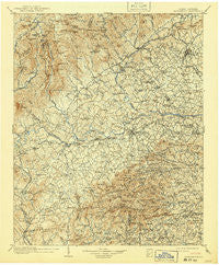
~ Morganton NC topo map, 1:125000 scale, 30 X 30 Minute, Historical, 1905, updated 1941
Morganton, North Carolina, USGS topographic map dated 1905.
Includes geographic coordinates (latitude and longitude). This topographic map is suitable for hiking, camping, and exploring, or framing it as a wall map.
Printed on-demand using high resolution imagery, on heavy weight and acid free paper, or alternatively on a variety of synthetic materials.
Topos available on paper, Waterproof, Poly, or Tyvek. Usually shipping rolled, unless combined with other folded maps in one order.
- Product Number: USGS-5374950
- Free digital map download (high-resolution, GeoPDF): Morganton, North Carolina (file size: 11 MB)
- Map Size: please refer to the dimensions of the GeoPDF map above
- Weight (paper map): ca. 55 grams
- Map Type: POD USGS Topographic Map
- Map Series: HTMC
- Map Verison: Historical
- Cell ID: 66094
- Scan ID: 163542
- Imprint Year: 1941
- Survey Year: 1903
- Datum: Unstated
- Map Projection: Polyconic
- Map published by United States Geological Survey
- Map Language: English
- Scanner Resolution: 600 dpi
- Map Cell Name: Morganton
- Grid size: 30 X 30 Minute
- Date on map: 1905
- Map Scale: 1:125000
- Geographical region: North Carolina, United States
Neighboring Maps:
All neighboring USGS topo maps are available for sale online at a variety of scales.
Spatial coverage:
Topo map Morganton, North Carolina, covers the geographical area associated the following places:
- Oak Hill - Pinewood - Linville River (historical) - Petche Gap - Smokey Creek - Glen Alpine - Town and Country - Mortimer - Perkinsville - Table Rock - Mountain Home (historical) - Joyceton - Morganton - Olivette - Altamont - Cajahs Mountain - Laurel Hill - Pinehurst - Thermal City - Ramsey - Forest Hills - Valmead - Warrior - Johnson Development - Corola Hills - Cold Springs - Wisemans View - Salem - Knob Creek - Shoups Ford - Charlesmont - Tremont Park - Three Mile - Dysartsville - Glenwood - Jonas Ridge - Ashford - Rollins (historical) - Heritage Hills - Camp Creek - Gold - Adako - Pleasant Grove - East Marion - Magnolia - Hartland - Sunnyside - Pine Mountain Lakes - Pineburr - Tarkey Tail (historical) - Olive Grove - Clinchfield - Linville - Nebo - Enola - Rufus - Calico Place - Oakmont Estates - Hickory Grove (historical) - North Cove - Parkhill - Happy Valley - Glenburine (historical) - Amherst - West Lenoir - New Home - Fairway Acres - Hampton Heights - Spencer Heights - Gamewell Heights - Abingdon - Baton - Connelly Springs - Stumptown - Lovelady (historical) - Gamewell - Calvin - Muttenz (historical) - Brown Mountain Beach - Petersburg - Fero - Linville Falls - Toluca - Longtown - Tranquil Hill - Cloverdale - Kawana - Patterson - Chesterfield - Burkemont - Rambling Acres - Patten - Hardaway (historical) - Globe Set (historical) - Vein Mountain - Trio (historical) - Jacktown - Yellow Gap - British Woods - Valdese
- Map Area ID: AREA3635.5-82-81.5
- Northwest corner Lat/Long code: USGSNW36-82
- Northeast corner Lat/Long code: USGSNE36-81.5
- Southwest corner Lat/Long code: USGSSW35.5-82
- Southeast corner Lat/Long code: USGSSE35.5-81.5
- Northern map edge Latitude: 36
- Southern map edge Latitude: 35.5
- Western map edge Longitude: -82
- Eastern map edge Longitude: -81.5


