
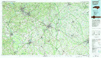
~ Laurinburg NC topo map, 1:100000 scale, 30 X 60 Minute, Historical, 1983, updated 1984
Laurinburg, North Carolina, USGS topographic map dated 1983.
Includes geographic coordinates (latitude and longitude). This topographic map is suitable for hiking, camping, and exploring, or framing it as a wall map.
Printed on-demand using high resolution imagery, on heavy weight and acid free paper, or alternatively on a variety of synthetic materials.
Topos available on paper, Waterproof, Poly, or Tyvek. Usually shipping rolled, unless combined with other folded maps in one order.
- Product Number: USGS-5374830
- Free digital map download (high-resolution, GeoPDF): Laurinburg, North Carolina (file size: 30 MB)
- Map Size: please refer to the dimensions of the GeoPDF map above
- Weight (paper map): ca. 55 grams
- Map Type: POD USGS Topographic Map
- Map Series: HTMC
- Map Verison: Historical
- Cell ID: 67828
- Scan ID: 162828
- Imprint Year: 1984
- Woodland Tint: Yes
- Aerial Photo Year: 1981
- Edit Year: 1983
- Datum: NAD27
- Map Projection: Universal Transverse Mercator
- Map published by United States Geological Survey
- Map Language: English
- Scanner Resolution: 600 dpi
- Map Cell Name: Laurinburg
- Grid size: 30 X 60 Minute
- Date on map: 1983
- Map Scale: 1:100000
- Geographical region: North Carolina, United States
Neighboring Maps:
All neighboring USGS topo maps are available for sale online at a variety of scales.
Spatial coverage:
Topo map Laurinburg, North Carolina, covers the geographical area associated the following places:
- Hillcrest - Fletcher - Lakeside - McDonalds - Sandy Bottoms - Red Springs - Diggs - Kingdale - West Rockingham - Montclair - Elmore - Alma - Carolina Park - Glenwood - Tindallsville (historical) - Gibson Mill - Richmond Mill - Gold Hill - McNeils (historical) - East Side Park - Woodrun - Cairo - Norman Heights - Five Points - Salem - McColl - Isgett Circle - Excelsior (historical) - Elrod - Red Bluff - Rennert - Langley Place Mobile Home Park - Hickson (historical) - Scottsdale - Pates - East Hamlet - Cognac - Alfordsville - Glen Acres - Raynham - Sunny Acres - Bunker Hill - Masons Crossroads - Old Hundred - Brocks Mill - Park Wood - Raeford - North View - Wagram - Oak Ridge Park - Hamlet - Dunbar - Blenheim - Westwood - Silver Hill - Laurinburg - Richmond Park Extension - Edgeland Park - Sunnybrook Heights - Antioch - Whispering Pines Number Two - Hasty - Green Pond - Wakulla - Phil - Tara Acres - Purvis - Monroe Crossroads - Crossway - Sinclair Crossroads - McFarlan - Raemon - McArthur Crossroads - Red Banks - Pembroke - College Park South - Yates Hill - Fulton - Sunshine Park - Gaineys Place - Old Sneedsboro - Sandy Grove - Lester - Edinburgh - Camelin Acres - Oakland Crossroads - Lake Terrace - New Town - Marlboro - Steen Town - Midway - Idlewood - Jimmys Mobile Court - Cheraw - Ayers (historical) - Brittland Mobile Home Park - Lincoln Heights - Gibson - McBryde Farm - McInnis (historical)
- Map Area ID: AREA3534.5-80-79
- Northwest corner Lat/Long code: USGSNW35-80
- Northeast corner Lat/Long code: USGSNE35-79
- Southwest corner Lat/Long code: USGSSW34.5-80
- Southeast corner Lat/Long code: USGSSE34.5-79
- Northern map edge Latitude: 35
- Southern map edge Latitude: 34.5
- Western map edge Longitude: -80
- Eastern map edge Longitude: -79


