
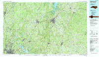
~ Henderson NC topo map, 1:100000 scale, 30 X 60 Minute, Historical, 1991, updated 1991
Henderson, North Carolina, USGS topographic map dated 1991.
Includes geographic coordinates (latitude and longitude). This topographic map is suitable for hiking, camping, and exploring, or framing it as a wall map.
Printed on-demand using high resolution imagery, on heavy weight and acid free paper, or alternatively on a variety of synthetic materials.
Topos available on paper, Waterproof, Poly, or Tyvek. Usually shipping rolled, unless combined with other folded maps in one order.
- Product Number: USGS-5374816
- Free digital map download (high-resolution, GeoPDF): Henderson, North Carolina (file size: 35 MB)
- Map Size: please refer to the dimensions of the GeoPDF map above
- Weight (paper map): ca. 55 grams
- Map Type: POD USGS Topographic Map
- Map Series: HTMC
- Map Verison: Historical
- Cell ID: 67660
- Scan ID: 162161
- Imprint Year: 1991
- Woodland Tint: Yes
- Aerial Photo Year: 1989
- Edit Year: 1991
- Datum: NAD27
- Map Projection: Universal Transverse Mercator
- Map published by United States Geological Survey
- Map Language: English
- Scanner Resolution: 600 dpi
- Map Cell Name: Henderson
- Grid size: 30 X 60 Minute
- Date on map: 1991
- Map Scale: 1:100000
- Geographical region: North Carolina, United States
Neighboring Maps:
All neighboring USGS topo maps are available for sale online at a variety of scales.
Spatial coverage:
Topo map Henderson, North Carolina, covers the geographical area associated the following places:
- Ridgeway - Pleasant Green Estates - Ingleside - Rocky Ford - Wilbourns - Archer Woods - Kellys Crossroads - Huckleberry Spring - Mangum Store - Willow Oaks - Braggtown - White Level - Triple Springs - Clay - Needmore - Oak Hill - Wilton - Katesville - Brooksdale - Mays Crossroads - Corinth - Warrenton - Purnell - Henderson - Fairntosh - Hickory Rock - Heritage Heights - Orange Factory - Satterwhite - Gill - Forest Acres - Willardville - Country Place - Roxboro - Seaman Way - Margaret - Jacksontown - Cokesbury - Centerville - Lickskillet - Greymoss - Cal-Vel - Burton - Oakville - Fox Run - Weaver - Sukey Young Crossroads - Rougemont - Rocky Knoll - Lyons - Sandy Plain - Meadow Estates - Drewry - Fairport - Afton - Hester - North Side - Culbreth - Floytan Crossroads - Creedmoor - West Hills - Grissom - Butner - Mount Energy - Bullocksville - Kearney - Edwards Crossroads - Hunters Ridge - Greenwood Acres - The American Village - Elberon - Louisburg - Dexter - Middleburg - Oine - Halloway (historical) - Macon - Berea - Cornwall - North Henderson - Epsom - Belltown - Hargrove Estates - Gentry Store - Catilina - Bullock - Mays Crossroads - Red Mountain - Matthews Crossroads - Alert - Lancaster Crossroads - Raynor - West Hills East - University Estates - Madison Park - Lake View - Pocomoke - Letha (historical) - Huntsboro - Stallings Crossroads
- Map Area ID: AREA36.536-79-78
- Northwest corner Lat/Long code: USGSNW36.5-79
- Northeast corner Lat/Long code: USGSNE36.5-78
- Southwest corner Lat/Long code: USGSSW36-79
- Southeast corner Lat/Long code: USGSSE36-78
- Northern map edge Latitude: 36.5
- Southern map edge Latitude: 36
- Western map edge Longitude: -79
- Eastern map edge Longitude: -78


