
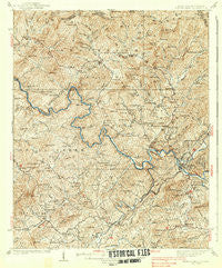
~ Fowler Bend NC topo map, 1:62500 scale, 15 X 15 Minute, Historical, 1938
Fowler Bend, North Carolina, USGS topographic map dated 1938.
Includes geographic coordinates (latitude and longitude). This topographic map is suitable for hiking, camping, and exploring, or framing it as a wall map.
Printed on-demand using high resolution imagery, on heavy weight and acid free paper, or alternatively on a variety of synthetic materials.
Topos available on paper, Waterproof, Poly, or Tyvek. Usually shipping rolled, unless combined with other folded maps in one order.
- Product Number: USGS-5374490
- Free digital map download (high-resolution, GeoPDF): Fowler Bend, North Carolina (file size: 13 MB)
- Map Size: please refer to the dimensions of the GeoPDF map above
- Weight (paper map): ca. 55 grams
- Map Type: POD USGS Topographic Map
- Map Series: HTMC
- Map Verison: Historical
- Cell ID: 54345
- Scan ID: 161417
- Survey Year: 1934
- Datum: NAD27
- Map Projection: Polyconic
- Map published by United States Geological Survey
- Map Language: English
- Scanner Resolution: 600 dpi
- Map Cell Name: Fowler Bend
- Grid size: 15 X 15 Minute
- Date on map: 1938
- Map Scale: 1:62500
- Geographical region: North Carolina, United States
Neighboring Maps:
All neighboring USGS topo maps are available for sale online at a variety of scales.
Spatial coverage:
Topo map Fowler Bend, North Carolina, covers the geographical area associated the following places:
- Texana - Postell - Hiwassee Village - Pleasant Valley - Vests - Grandview - Hothouse - Pleasant Hill - Friendship - Regal - Oak Park - Violet - Grape Creek - Unaka - Sunny Point - Bates Creek - Murphy - Letitia - Martins Creek - Ebenezer - Ogreeta - Boiling Springs
- Map Area ID: AREA35.2535-84.25-84
- Northwest corner Lat/Long code: USGSNW35.25-84.25
- Northeast corner Lat/Long code: USGSNE35.25-84
- Southwest corner Lat/Long code: USGSSW35-84.25
- Southeast corner Lat/Long code: USGSSE35-84
- Northern map edge Latitude: 35.25
- Southern map edge Latitude: 35
- Western map edge Longitude: -84.25
- Eastern map edge Longitude: -84


