
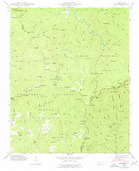
~ Sam Knob NC topo map, 1:24000 scale, 7.5 X 7.5 Minute, Historical, 1946, updated 1977
Sam Knob, North Carolina, USGS topographic map dated 1946.
Includes geographic coordinates (latitude and longitude). This topographic map is suitable for hiking, camping, and exploring, or framing it as a wall map.
Printed on-demand using high resolution imagery, on heavy weight and acid free paper, or alternatively on a variety of synthetic materials.
Topos available on paper, Waterproof, Poly, or Tyvek. Usually shipping rolled, unless combined with other folded maps in one order.
- Product Number: USGS-5373096
- Free digital map download (high-resolution, GeoPDF): Sam Knob, North Carolina (file size: 11 MB)
- Map Size: please refer to the dimensions of the GeoPDF map above
- Weight (paper map): ca. 55 grams
- Map Type: POD USGS Topographic Map
- Map Series: HTMC
- Map Verison: Historical
- Cell ID: 39549
- Scan ID: 164840
- Imprint Year: 1977
- Woodland Tint: Yes
- Field Check Year: 1946
- Datum: NAD27
- Map Projection: Polyconic
- Map published by Tennessee Valley Authority
- Map Language: English
- Scanner Resolution: 600 dpi
- Map Cell Name: Sam Knob
- Grid size: 7.5 X 7.5 Minute
- Date on map: 1946
- Map Scale: 1:24000
- Geographical region: North Carolina, United States
Neighboring Maps:
All neighboring USGS topo maps are available for sale online at a variety of scales.
Spatial coverage:
Topo map Sam Knob, North Carolina, covers the geographical area associated the following places:
- Bryson Knob - Courthouse Creek - Little Beartrap Ridge - Pinhook Creek - Haywood Gap Stream - Big Fork Ridge - Mill Station Creek - Pinhook Gap - Rough Butt Bald - Wash Hollow - Coalney Branch - Gage Ridge - Tanasee Bald - Great Balsam Mountains - Reinhart Gap - Cathey Ridge - Birdstand Mountain - Bubbling Spring Branch - Neddie Mountain - Chestnut Bald - Bearpen Branch - Grassy Ridge Branch - Reinhart Knob - Devil's Courthouse Tunnel - Courthouse Ridge - Black Mountain - Herrin Knob - Sugar Cove - Possum Hollow - Courthouse Falls - Little Beartrap Branch - Cub Branch - Camp Two Branch - Little Sam Knob - Gage Creek - Summey Cove - Big Beartrail Ridge - Camp Creek - Beetree Fork - Brushy Ridge - Flat Laurel Creek - Parker Knob - Wet Camp Gap - Charley Bald - Middle Prong West Fork Pigeon River - Cathey Gap - Fork Ridge - Rich Mountain Bald - Hemlock Branch - Tom Creek - Fire Scald Ridge - Charley Knob - Charley Ridge - Township of Cecil - Sassafras Creek - Sam Branch - Boomer Inn Branch - Sunburst Recreation Area - Beartrap Ridge - Silvermine Bald - Kiesee Creek - Green Knob - Sam Knob - Green Ridge - Buck Knob - Chestnut Ridge - Charley Creek School - Chestnut Creek - Big Beartrap Branch - Beartrail Ridge Gap - Yellow Patch Branch - Green Creek - Rocky Knob Gap - Richland Gap - Turnpike Creek - Bald Knob Branch - Panther Branch - Deep Gap - Wolf Mountain - Rich Mountain - Little Bearpen Gap - Richland Balsam - Beech Gap - Buckeye Gap - Gage Gap - Mount Hardy - Camp Mountain - Wolf Bald - Devils Courthouse - Bearpen Gap - Cold Creek - Buckeye Creek - Middle Prong Wilderness - Sweetwater Spring - Gage Bald - Cold Spring Gap - Rocky Knob - Right Hand Prong West Fork Pigeon River - Balsam Lake - Shining Rock Creek
- Map Area ID: AREA35.37535.25-83-82.875
- Northwest corner Lat/Long code: USGSNW35.375-83
- Northeast corner Lat/Long code: USGSNE35.375-82.875
- Southwest corner Lat/Long code: USGSSW35.25-83
- Southeast corner Lat/Long code: USGSSE35.25-82.875
- Northern map edge Latitude: 35.375
- Southern map edge Latitude: 35.25
- Western map edge Longitude: -83
- Eastern map edge Longitude: -82.875


