
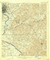
~ Columbus GA topo map, 1:62500 scale, 15 X 15 Minute, Historical, 1908, updated 1931
Columbus, Georgia, USGS topographic map dated 1908.
Includes geographic coordinates (latitude and longitude). This topographic map is suitable for hiking, camping, and exploring, or framing it as a wall map.
Printed on-demand using high resolution imagery, on heavy weight and acid free paper, or alternatively on a variety of synthetic materials.
Topos available on paper, Waterproof, Poly, or Tyvek. Usually shipping rolled, unless combined with other folded maps in one order.
- Product Number: USGS-5364740
- Free digital map download (high-resolution, GeoPDF): Columbus, Georgia (file size: 9 MB)
- Map Size: please refer to the dimensions of the GeoPDF map above
- Weight (paper map): ca. 55 grams
- Map Type: POD USGS Topographic Map
- Map Series: HTMC
- Map Verison: Historical
- Cell ID: 52838
- Scan ID: 247399
- Imprint Year: 1931
- Survey Year: 1907
- Datum: NAD
- Map Projection: Polyconic
- Map published by United States Geological Survey
- Map Language: English
- Scanner Resolution: 600 dpi
- Map Cell Name: Columbus
- Grid size: 15 X 15 Minute
- Date on map: 1908
- Map Scale: 1:62500
- Geographical region: Georgia, United States
Neighboring Maps:
All neighboring USGS topo maps are available for sale online at a variety of scales.
Spatial coverage:
Topo map Columbus, Georgia, covers the geographical area associated the following places:
- Avondale Heights - Pine Hill - Levy - Oakland Park - Rose Hill Heights - East Lakes - Wickham Heights - Taylors Woods - Magnolia Grove - Hilton Heights - Parkchester - Cottage Mills (historical) - City View Heights - Hampton Heights - Willis Plaza - Alta Vista - Cusseta Heights - Avondale - Muscogee Manor - Merrywood - Branton Woods - Woolfolk (historical) - Englewood - Franklin Acres - Boxwood Estates - Briarwood - Edgewood - Amber Acres - Esquiline Heights - Columbia Heights - Uchi (historical) - Carriage Estates - Carter Acres - Vista Terrace - Dimon Head - Brookridge - Willett - Glen Arden - Hillside Terrace - Garrett Heights - Regency Park - Holiday Park - Yuchi (historical) - Highland Park - Baker Village - Pinewood - Pembrook - Fort Benning - Columbus - Edgewood Terrace - Benning Park - Cusseta - Linden - Ridgeview Heights - McGraw Manor - Meadow Wood Park - East Edgewood - McDaniel Manor - Ridgefield Heights - Allison Estates - North Highlands - Wesley Heights - Battle Forest - Benning Hills - Farrwood Park - Saint Marys Hills - Shack (historical) - Eelbeck - Wynnton Grove - Wellington - Cherokee Park - Sand Hill - Belvedere Park - Holly Hills - Bibb City - Dinglewood - Sunset Terrace - Crossgate - Broadmoor - Brookhaven - Woodlawn Estates - Lindsey Park - Battle Park - Central Springs - Kasihta (historical) - Halloca (historical) - Apalatchukla (historical) - Northstar - Wynnton - Sheraton Forest - Andrew Woods - Holly Woods - Clubview Heights - Jamestown - Floyd Grove - City Village - Muscogee - Quail Creek - Edgewood Forest - Valley Hills
- Map Area ID: AREA32.532.25-85-84.75
- Northwest corner Lat/Long code: USGSNW32.5-85
- Northeast corner Lat/Long code: USGSNE32.5-84.75
- Southwest corner Lat/Long code: USGSSW32.25-85
- Southeast corner Lat/Long code: USGSSE32.25-84.75
- Northern map edge Latitude: 32.5
- Southern map edge Latitude: 32.25
- Western map edge Longitude: -85
- Eastern map edge Longitude: -84.75


