
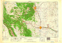
~ Pueblo CO topo map, 1:250000 scale, 1 X 2 Degree, Historical, 1962
Pueblo, Colorado, USGS topographic map dated 1962.
Includes geographic coordinates (latitude and longitude). This topographic map is suitable for hiking, camping, and exploring, or framing it as a wall map.
Printed on-demand using high resolution imagery, on heavy weight and acid free paper, or alternatively on a variety of synthetic materials.
Topos available on paper, Waterproof, Poly, or Tyvek. Usually shipping rolled, unless combined with other folded maps in one order.
- Product Number: USGS-5359833
- Free digital map download (high-resolution, GeoPDF): Pueblo, Colorado (file size: 15 MB)
- Map Size: please refer to the dimensions of the GeoPDF map above
- Weight (paper map): ca. 55 grams
- Map Type: POD USGS Topographic Map
- Map Series: HTMC
- Map Verison: Historical
- Cell ID: 68976
- Scan ID: 707538
- Woodland Tint: Yes
- Edit Year: 1962
- Field Check Year: 1954
- Datum: Unstated
- Map Projection: Transverse Mercator
- Map published by United States Army Corps of Engineers
- Map published by United States Army
- Map Language: English
- Scanner Resolution: 508 dpi
- Map Cell Name: Pueblo
- Grid size: 1 X 2 Degree
- Date on map: 1962
- Map Scale: 1:250000
- Geographical region: Colorado, United States
Neighboring Maps:
All neighboring USGS topo maps are available for sale online at a variety of scales.
Spatial coverage:
Topo map Pueblo, Colorado, covers the geographical area associated the following places:
- Marigold - Coaldale - Gillett (historical) - Cripple Creek - Cleora - Nyberg - Divide - Buckskin Joe - Rosita - Beacon Hill - Rosemont - Prospect Heights - Duffield - Howard - Henkel - Avondale - Querida - Rockvale - Truckton - Valley View - Ula (historical) - Old Mountain View (historical) - Skinners - Ivywild - Chandler (historical) - Stratton - Fearnowville - Wigwam - Williamsburg - Concrete - Hamlet - Adelaide - Haver - Papeton - Fort Carson - Beulah Valley - Newett - Minnehaha - Whitehorn - Lake George - Sample - Stratmoor - Chipita Park - Pleasanton - Wild Horse - Tanglewood Acres - Ellicott - Swallows - Turret - Lombard Village - Silver Cliff - Pueblo West - Orchard Park - Stratton Meadows - Coal Creek - Fink - Rock Creek Park - Florence - Altman (historical) - Fairview - Salida - Green Settlement - Stem Beach - Rush - Echo - Fowler - Woodland Park - Futurity - Goldfield - Independence (historical) - Crystola - Penrose - Pikeview - Fort Reynolds - Manitou Springs - Anaconda (historical) - Baxter - Green Mountain Falls - Yorkville - Galena - Hobson - Fountain - Cascade - Colorado Springs - Brookside - Sikes - Widefield - Elkton - Salt Creek - Florissant - Goodnight - North Avondale - Balfour - Blende - Falcon - Midway - Buttes - Vallie - Kelker - Lincoln Park
- Map Area ID: AREA3938-106-104
- Northwest corner Lat/Long code: USGSNW39-106
- Northeast corner Lat/Long code: USGSNE39-104
- Southwest corner Lat/Long code: USGSSW38-106
- Southeast corner Lat/Long code: USGSSE38-104
- Northern map edge Latitude: 39
- Southern map edge Latitude: 38
- Western map edge Longitude: -106
- Eastern map edge Longitude: -104


