
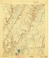
~ Chattanooga TN topo map, 1:125000 scale, 30 X 30 Minute, Historical, 1893
Chattanooga, Tennessee, USGS topographic map dated 1893.
Includes geographic coordinates (latitude and longitude). This topographic map is suitable for hiking, camping, and exploring, or framing it as a wall map.
Printed on-demand using high resolution imagery, on heavy weight and acid free paper, or alternatively on a variety of synthetic materials.
Topos available on paper, Waterproof, Poly, or Tyvek. Usually shipping rolled, unless combined with other folded maps in one order.
- Product Number: USGS-5338932
- Free digital map download (high-resolution, GeoPDF): Chattanooga, Tennessee (file size: 7 MB)
- Map Size: please refer to the dimensions of the GeoPDF map above
- Weight (paper map): ca. 55 grams
- Map Type: POD USGS Topographic Map
- Map Series: HTMC
- Map Verison: Historical
- Cell ID: 65175
- Scan ID: 153496
- Survey Year: 1886
- Datum: Unstated
- Map Projection: Unstated
- Map published by United States Geological Survey
- Map Language: English
- Scanner Resolution: 600 dpi
- Map Cell Name: Chattnooga
- Grid size: 30 X 30 Minute
- Date on map: 1893
- Map Scale: 1:125000
- Geographical region: Tennessee, United States
Neighboring Maps:
All neighboring USGS topo maps are available for sale online at a variety of scales.
Spatial coverage:
Topo map Chattanooga, Tennessee, covers the geographical area associated the following places:
- Dale Acres - Garden Farms - Bayview - North Tower Forest - Talley Place - Mountain View - Laurel Creek - Avondale - Holly Heights - New Hope - Palisades - Dayton - Stoneridge - Bryant - Jersey - Oak Grove - Signal Hills - Fairmount - Duncan Hills - Shepherd - Smithtown - Riggs Trailer Park - Shake Rag - Creekwood Terrace - Royal Oaks - Fairhills - Signal Terrace - Eastdale - Hampton Woods - Hillsboro Heights - Shelton Estates - Rivermont - River Hills - Richland Crest - Huntingdon Forest - Easton Terrace - Brynewood Park - Liberty - Farrington Forest - Ridgedale - Birnam Wood - Ware Branch - Lone Oak - Shawnee Park - Shady Grove - South Brainerd - North Brainerd - Gaylan Heights - Valley Village - Blue Springs - Stuart Heights - Opossum Creek Pines - Sale Creek - Claridge - Irongate - Shallowford Hills - Fountain Village - Parkshore Estates - Caramel Village - Condra - Savannah Peninsula - Lakeside Park - Greens Mill - Middle Valley Estates - Spring Valley - Theresa Heights - Harrison Point - Washington Heights - Cloverdale Estates - Springvale - Olde Mill - Edwards Point - Norcross Hills - Camp Jordan - Sandalwood Village - Marimont - Long Branch - Daus - J And B Mobile Home Park - Foxwood Heights - Cross Creek - Soddy Lake Heights - Andrea Heights - Auburn Hills - Lower Mill - Riverchase - Lakesite - Mount Airy - Northshore Hills - Snow Hill - River Oaks - Brookfield - Tiftonia - Chattanooga - Radmoor - Morrison Springs - Mile Straight - Highland Manor - Fairview - Springcrest
- Map Area ID: AREA35.535-85.5-85
- Northwest corner Lat/Long code: USGSNW35.5-85.5
- Northeast corner Lat/Long code: USGSNE35.5-85
- Southwest corner Lat/Long code: USGSSW35-85.5
- Southeast corner Lat/Long code: USGSSE35-85
- Northern map edge Latitude: 35.5
- Southern map edge Latitude: 35
- Western map edge Longitude: -85.5
- Eastern map edge Longitude: -85


