
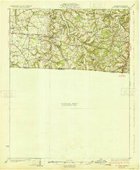
~ Adolphus KY topo map, 1:62500 scale, 15 X 15 Minute, Historical, 1931
Adolphus, Kentucky, USGS topographic map dated 1931.
Includes geographic coordinates (latitude and longitude). This topographic map is suitable for hiking, camping, and exploring, or framing it as a wall map.
Printed on-demand using high resolution imagery, on heavy weight and acid free paper, or alternatively on a variety of synthetic materials.
Topos available on paper, Waterproof, Poly, or Tyvek. Usually shipping rolled, unless combined with other folded maps in one order.
- Product Number: USGS-5338628
- Free digital map download (high-resolution, GeoPDF): Adolphus, Kentucky (file size: 5 MB)
- Map Size: please refer to the dimensions of the GeoPDF map above
- Weight (paper map): ca. 55 grams
- Map Type: POD USGS Topographic Map
- Map Series: HTMC
- Map Verison: Historical
- Cell ID: 50334
- Scan ID: 153408
- Woodland Tint: Yes
- Survey Year: 1928
- Datum: NAD
- Map Projection: Polyconic
- Preliminary map: Yes
- Map published by United States Geological Survey
- Map Language: English
- Scanner Resolution: 600 dpi
- Map Cell Name: Adolphus
- Grid size: 15 X 15 Minute
- Date on map: 1931
- Map Scale: 1:62500
- Geographical region: Kentucky, United States
Neighboring Maps:
All neighboring USGS topo maps are available for sale online at a variety of scales.
Spatial coverage:
Topo map Adolphus, Kentucky, covers the geographical area associated the following places:
- Turners Station - Rock Bridge - Sulphura - Providence - Bornes Ford - Brackentown - Sugar Grove - Red Hill - Withamtown - Chapel Hill - Nubia - Pipers Chapel - Bransford - Angeltown - Hickory Flat - New Roe - Oak Grove - Bledsoe - Round Pond (historical) - Chestnut Hill - Pondville - McElroy Ford - Fountain Head - Fairfield - Adolphus - Mount Vernon - Fleet - Liberty - Highland - Clare - Smyrna (historical) - Corinth - Alonzo - Sengtown - Highland - Hop Over (historical) - Eubanks Ford - Bon Air
- Map Area ID: AREA36.7536.5-86.5-86.25
- Northwest corner Lat/Long code: USGSNW36.75-86.5
- Northeast corner Lat/Long code: USGSNE36.75-86.25
- Southwest corner Lat/Long code: USGSSW36.5-86.5
- Southeast corner Lat/Long code: USGSSE36.5-86.25
- Northern map edge Latitude: 36.75
- Southern map edge Latitude: 36.5
- Western map edge Longitude: -86.5
- Eastern map edge Longitude: -86.25


