
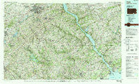
~ York PA topo map, 1:100000 scale, 30 X 60 Minute, Historical, 1983, updated 1988
York, Pennsylvania, USGS topographic map dated 1983.
Includes geographic coordinates (latitude and longitude). This topographic map is suitable for hiking, camping, and exploring, or framing it as a wall map.
Printed on-demand using high resolution imagery, on heavy weight and acid free paper, or alternatively on a variety of synthetic materials.
Topos available on paper, Waterproof, Poly, or Tyvek. Usually shipping rolled, unless combined with other folded maps in one order.
- Product Number: USGS-5332014
- Free digital map download (high-resolution, GeoPDF): York, Pennsylvania (file size: 32 MB)
- Map Size: please refer to the dimensions of the GeoPDF map above
- Weight (paper map): ca. 55 grams
- Map Type: POD USGS Topographic Map
- Map Series: HTMC
- Map Verison: Historical
- Cell ID: 68625
- Scan ID: 223698
- Imprint Year: 1988
- Woodland Tint: Yes
- Aerial Photo Year: 1982
- Edit Year: 1983
- Datum: NAD27
- Map Projection: Universal Transverse Mercator
- Map published by United States Geological Survey
- Map Language: English
- Scanner Resolution: 600 dpi
- Map Cell Name: York
- Grid size: 30 X 60 Minute
- Date on map: 1983
- Map Scale: 1:100000
- Geographical region: Pennsylvania, United States
Neighboring Maps:
All neighboring USGS topo maps are available for sale online at a variety of scales.
Spatial coverage:
Topo map York, Pennsylvania, covers the geographical area associated the following places:
- Cedar Grove - Level - Shawnee - Taxville - Kempfield - Bethel - Dominos Acres - Quarryville - Southside - Osborne - Scarboro - Kirks Mills - Iva - Bonnair - Hillview - Pegasus Estates - Curtis Acres - Cherry Hill - Graybill - Stoney Forest Estates - Pleasant Acres - Allendale Estates - Campus Heights - Pinehurst - Sweet Air Manor - North Hills - Sylvan Hills - Grafton Shops (historical) - My Ladys Manor Estates - Wakely Terrace - Morgan Manor - Rock Acres - Rockdale - Shiloh - Greendale Estates - Charbonnet - Principio Furnace - Butler - Corns Manor - Gross Mill Estates - Mountain Hill - Tome Estates - Coldstream - Hollinsland - Sylmar - Big Mount - Panorama Hills - Greenbrier Hills - Buena Vista Estates - Ridgefield - Parkshire - Vale Hills - Woodsbrook - Laurel Brook - Whitehouse - New Texas - Keeney Mill Woods - Centerville - Fenmore - Reeds Village - Brodbecks - Burkley Manor - Southwood Hills - Cherby-Maurlyn Estates - Scotsdale - Davidsburg - Willwood - Bar Kess Heights - Winters Run - Greenbrier - Proctors Seat - Grafton Heights - Marywood - Mount Zoar - Brilhart Terrace - Stoverstown - Oak Dale - Putnam Hill - Lampeter - Briar Ridge - Spring House Estates - Fairmount North - Gatchellville - Lynwood - Huntington - Hickory Hills - Carroll Meadows - Mill Green Acres - Brummel - Crestview - Evergreen Hills - Sunset Way - Beckley Estates - Lawndale - Linden Springs - England Estates - Black Baron - Craigtown - Allana Acres - Voshelle
- Map Area ID: AREA4039.5-77-76
- Northwest corner Lat/Long code: USGSNW40-77
- Northeast corner Lat/Long code: USGSNE40-76
- Southwest corner Lat/Long code: USGSSW39.5-77
- Southeast corner Lat/Long code: USGSSE39.5-76
- Northern map edge Latitude: 40
- Southern map edge Latitude: 39.5
- Western map edge Longitude: -77
- Eastern map edge Longitude: -76


